
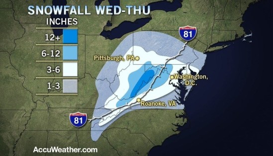
This map shows the total snowfall expected from Wednesday into Thursday. It shows all of the snow staying to our south this time around. As of tonight it is looking like we might slip into the extreme northern edge of this storm and get a little something in the way of rain and snow showers Wednesday night into Thursday. We will definitely be seeing very strong winds and some coastal flooding no matter which track it takes. It still looks like we will not be taking the brunt of this storm here in southern CT, but don’t let your guard down yet there is still an outside chance it takes a left and drops some heavier snow and rain. Stayed tuned -SS

If this storm does hit CT when can we expect to see precipitation?
It should get going by early afternoon on Wednesday. It should start as rain showers and then transition over to snow by the evening…