
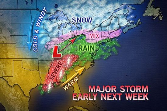
Just throwing it out there… We are watching the potential for another winter storm for early next week. This is the winter that just won’t quit! The storm should get here for Monday with another mixed bag of precipitation! Ill keep you posted! -SS

Just throwing it out there… We are watching the potential for another winter storm for early next week. This is the winter that just won’t quit! The storm should get here for Monday with another mixed bag of precipitation! Ill keep you posted! -SS

Just a little quick hitting storm tonight into tomorrow morning with scattered wet snow showers and flurries. Shouldn’t be a whole lot. Just might make for some slick conditions in spots. -SS
As predicted, we got a few inches of snow last night. Overnight as warmer air moved in and temperatures rose above freezing, the snow transitioned to freezing rain, sleet, and finally rain. The rain will taper off to showers later on this evening. Be careful when venturing out as there might still be some slick spots on untreated side roads and sidewalks. Temperatures in a few inland spots are still below freezing, and icing conditions can still exist. Take it slow out there! Off to VT for me to enjoy this fresh powder on the slopes! -SS
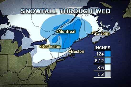
As you can see with this latest map, the extent of heavier snow has greatly increased. 3-6 inches can now be expected all the way to the coast of Connecticut. Interior sections are looking at a widespread area of over one foot!!
This map doesn’t show the accumulation of ice on top of that snow. Southern New England could get up to an additional half inch of ice. This accompanied with the heavy wet snow and strong winds till take down lots of trees and power lines in the heavily iced areas. Stay Tuned! -SS

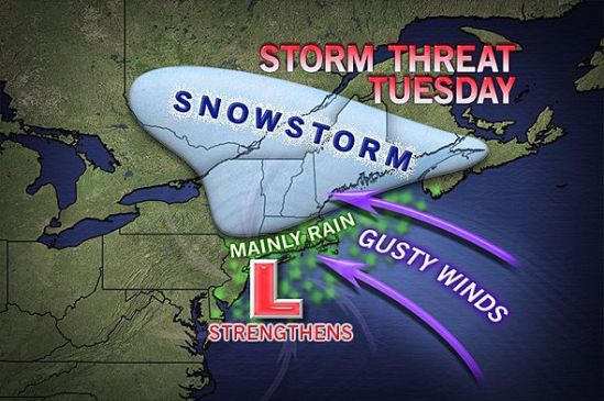
I’m not even sure where to start with this today!! All the ingredients are coming together to make this a monster storm. This storm will begin to move into the area tonight with snow for all locations. The snow will continue into the overnight, but this is where it gets tricky. As this storm moves in, it is going to transfer its energy to a new storm which will develop off of the New Jersey coast and move to the north or northeast.
This is going to be a tough one to call, when the new storm forms and then strengthens, so will the east and northeast winds. They will usher in lots of moisture, but also some warmer air aloft. The warm air will fill in the upper levels of the atmosphere, but not at the surface. This will lead to a prolonged period of sleet and freezing rain. This could fall heavy at times late tonight into Tuesday morning. This will be a tough one for accumulations, but it now looks like a general 3-5 inches all the way to New Haven. There will be some higher elevations in the hills of Connecticut that see 6-10 inches. If you go north from there into northern New England, they will be measuring in FEET of snow. With the ice, some of the valleys in southern Connecticut could be stuck just at or below freezing therefore extending the icing period into the morning. Use extreme caution in icy conditions, as 4 wheel drive does not help with braking on icy surfaces. There will be an accumulation of ice and sleet on top of the fallen snow which will make for extremely dangerous conditions.
This is a very potent storm that needs to be watched closely. The end of the afternoon commute tonight could get sloppy, but the main concern will be the Tuesday morning commute. Expect numerous school closings and delays for Tuesday. More to come! -SS
Well here comes another big complex storm into the area for Monday night into Tuesday. Inland portions of the northeast could see well over a foot from this storm!! Closer to the coast of Connecticut, we should only see a slushy inch or two before it mixes and changes to rain on Tuesday morning. This is going to have to be watched closely as some spots might hang close to the freezing mark early Tuesday, and there could be a prolonged period of freezing rain.
This will heavily impact travel for the Tuesday morning commute! Take the necessary precautions and take it slow out there! Any spots that get a substantial amount of this heavy wet snow, need to be prepared for the chance of power outages. The wet snow will cling to the tree limbs and power lines, and the strong winds will combine to bring many of these limbs and power lines down! Stay tuned for the latest! -SS
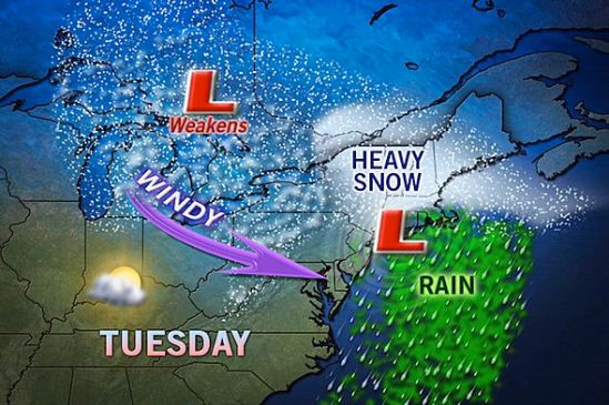
As it looks right now, northern New England looks to be in the bulls eye for heavy snow on this one. This storm will move in later in the day on Monday. It could start as some snow or mixed precipitation for everybody all the way to the coast. The storm will strengthen off the coast and wrap in lots of moisture and warmer air which will change any mix or snow to all rain for Connecticut. There are still some uncertainties with the exact track, and a little deviation could mean more snow for parts of Connecticut. As it gets closer, we will have a better idea of how much snow! I will keep you posted! -SS
This storm is still something to watch. It looks like a big mess of precipitation coming into the area sometime Monday afternoon or evening. It will drop some heavy snow inland and a mix of precip for the coast. There is going to be more coastal flooding and also wind gusts of 50-60 mph. As it gets closer we”ll have a better idea of what kind and how much precip will fall. I’ll keep you posted! -SS
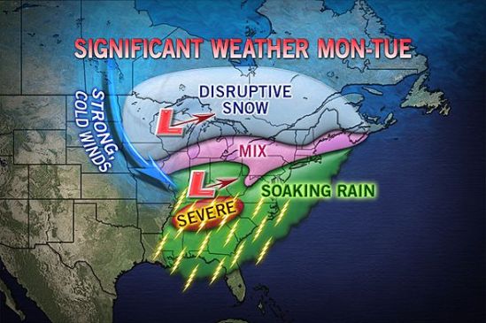
We are also watching the chance of a potent storm coming together somewhere in the time frame of Monday-Wednesday for the northeast. While it looks to be a mainly rain event here in Connecticut, inland portions need to watch this very closely. It could drop a good deal of heavy wet snow and rain on already very saturated soil from this weeks rain and melting snow. This will pose a flooding risk for lots of people in its path. This is something to watch, and I will keep you posted! -SS

We still have our eyes on a fast moving relatively weak storm for Friday night into Saturday night. This shouldn’t be more than wintry mix from Friday night into just plain rain during the day on Saturday. It may mix with or change back to snow for Saturday night. All in all there is not a lot of precipitation associated with this, but we still need to watch it. -SS
