Severe weather awareness week

Severe weather awareness week

This week is severe weather awareness week here in New England.

Here are some severe weather terms and definitions.

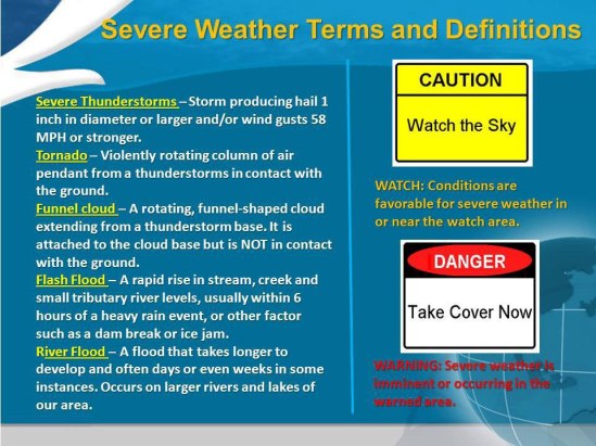
Severe thunderstorms are defined as those thunderstorms that produce winds of 58 mph or greater and or hail of one inch in diameter or larger. A Severe Thunderstorm Watch means that severe thunderstorms are possible over the next several hours. You should continue with your daily routine…but be prepared to move to a place of safety should a Severe Thunderstorm Warning be issued. A Severe Thunderstorm Warning means that severe thunderstorms are imminent or occurring. A warning implies a significant threat to life and property. You should seek shelter immediately when a Severe Thunderstorm Warning is issued.

Tornadoes are violently rotating columns of air in contact with the ground and attached to the cloud base above. Like a Severe Thunderstorm Watch…a Tornado Watch means that tornadoes are possible over the next several hours. A Tornado Warning means that a tornado is imminent or occurring. A Tornado Warning implies an immediate threat to life and property. Take shelter in a basement or interior room immediately.

Flash flooding is a rapid rise of water along a stream or low lying urban area. The most common cause of flash flooding is downpours associated with thunderstorms. A Flash Flood Watch means that conditions are favorable for flash flooding. Continue with your daily activities…but be prepared to head to a place of safety should a Flash Flood Warning be issued. A Flash Flood Warning means that flooding is imminent or occurring. Flood waters can rise rapidly. Seek High Ground immediately when a Flash Flood Warning is issued.

The National Weather Service issues severe thunderstorm, tornado, and flash flood warnings for the area likely to be impacted by the storm. Rather than for an entire County. This method Narrows the region for which a warning is valid, eliminating unnecessary warnings for areas of a County where no threat exists.

Severe weather season is right around the corner. Know these terms to better protect your life and property. Stay safe! -SS

Beautiful Saturday on tap

Beautiful Saturday on tap

With abundant sunshine warming things up nicely, and light winds, it’s a great day out there! The nice weather will continue into tomorrow, with temperatures nearing 70. This is the start of a prolonged period of warm and tranquil weather throughout the rest of the week. Enjoy it! -SS

Nice Friday on tap

Nice Friday on tap

A nice day on the way, with an upper level disturbance exiting the region this morning with clouds and a spotty sprinkle giving way to increasing sunshine into this afternoon as high pressure returns. A moderating trend will then begin into the upcoming weekend with a stretch of dry and pleasant weather looking to persist for several days as high pressure remains in control. Get out there this weekend and take it in! -SS

Cooler, but sunny out there

Cooler, but sunny out there

A nice day shaping up today, as a cold front has cleared the region this morning and a ridge of high pressure will nose in for today with some morning clouds giving way to increasing sunshine and cooler temperatures in the upper 50’s to around 60. A west-northwesterly breeze will also remain a bit gusty into the afternoon…

The extended forecast looks great! With no precip through the weekend, and a gradual warming trend! Get out and enjoy it! -SS

Heavy storms still moving east

Heavy storms still moving east

The storms and downpours are expected to increase in strength due to the building warmth of the afternoon and then remain strong into the evening.

Spotty showers will occur ahead of the line of storms and downpours during the day Friday and Friday evening. A prevailing cool wedge of air and/or clouds may limit the intensity of the storms over central and eastern New England.

Some locations can be hit by more than just a downpour and some lightning and thunder. A few places can have a severe thunderstorm that brings strong winds, torrential downpours and hail. As a result, there is the potential for downed trees, power outages and flash flooding in the vicinity of the storms.

The greatest chance of severe weather stretches from part of southeastern Pennsylvania to coastal South Carolina from late Friday afternoon into the evening.

The storms are the remnants of a squall line that affected the Central states with severe thunderstorms and flooding during the middle of the week.

It will not be until the evening before they reach most places along the middle and southern Atlantic coast and generally not until the overnight and early Saturday morning hours before they reach the east coast of New England.

There is the potential for 1-2 inches of rain along a large part of the Atlantic Seaboard later Friday and Friday night. -SS

Rain and thunder to end the week

Rain and thunder to end the week

A cold front bringing severe weather to the Midwest and the Mississippi Valley Thursday will reach the East on Friday producing rain, and locally gusty thunderstorms.

While the intensity of the thunderstorms will depend to some extent on the timing, and on how warm locations become during the day. Most locations from Florida to Maine will get a period of drenching rain. Areas most likely to experience localized strong to severe thunderstorms will be generally near and south of the Mason-Dixon line.

Some locations can be hit by more than just a downpour and some lightning and thunder. A few places can have a severe thunderstorm that brings strong winds, torrential downpours and hail. As a result, there is the potential for downed trees, power outages and flash flooding in the vicinity of the storms.

The storms will be the remnants of a squall line affecting the Central states today into tonight. It will not be until the overnight and early Saturday morning hours before they reach the east coast of New England.

There is the potential for 1-2 inches of rain along a large part of the Atlantic Seaboard. Much cooler and drier air will sweep in over much of the Eastern states this weekend. Wet snowflakes could even mix in over the highest elevations of northern Pennsylvania and upstate New York Saturday. -SS

Warm-up brings allergies

Warm-up brings allergies

Seasonal allergies will be in full swing this week in the Northeast as seasonable temperatures take hold. After a slow start to spring, more consistent, higher temperatures have finally migrated northward.

However, with these warmer temperatures comes the return of seasonal allergies. With milder conditions starting in the beginning of April, the growing season has really started up. Plants and flowers all over the region are blooming or are ready to pop.

This sudden boom in tree blossoms could have allergy sufferers seeing symptoms more abruptly than usual.
As per this time of year, the tree pollen is the main allergy threat, especially from oak, maple, pine and elm varieties.

What seems to have awakened the trees was the sudden warmth early last week, followed by drenching rain in many areas. Even though temperatures slipped back following the rain, they have averaged about 10 degrees higher than the first week of the month.

Consistent warmth is expected through this week, along with occasional rainfall. The combination of the two will continue to spur on blossoming and pollen release.

Even though rain temporarily removes some of the pollen from the air, it promotes a new round of blossoming this time of the year. -SS