Steamy then stormy weekend

Steamy then stormy weekend

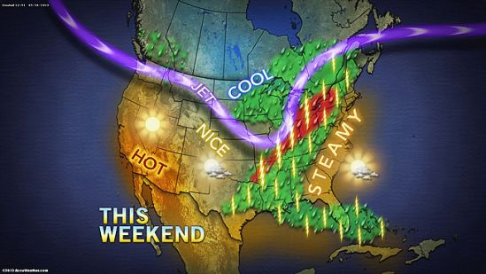
During the upcoming weekend, the heat will be chopped down over the Midwest by an advancing zone of thunderstorms associated with a cold front. The storms could be locally severe.

The cold front and storms would reach the Appalachians Saturday night and Sunday then the I-95 corridor by Monday. -SS

The heat is on

The heat is on

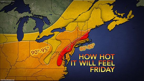
Midsummer heat is arriving just a few days after the unofficial start of the season. After shivering cold over the Memorial Day weekend, record-challenging heat will build. Some locations will experience a 50- to 55-degree temperature rise compared to morning lows this past weekend to afternoon highs Thursday to Saturday. -SS

Memorial Day weekend snow!

Memorial Day weekend snow!

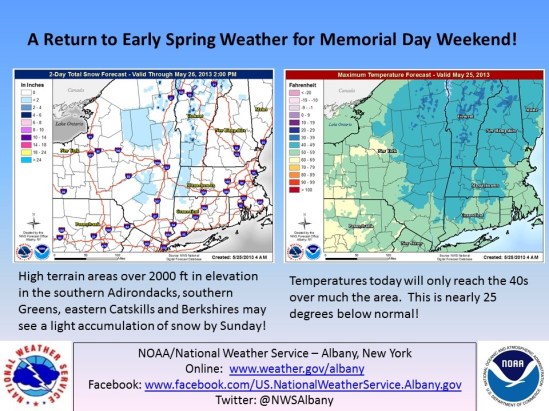
Forget the beaches this weekend, and hit the ski slopes! Unbelievable weather this weekend with up to a foot of snow possible in northern VT!! Temperatures are 20-25 degrees below normal! This is unprecedented late season snow! Summer is going to have to wait until the end of this week, when temps will reach into the 80s again! -SS

Strong storms today!!

Strong storms today!!

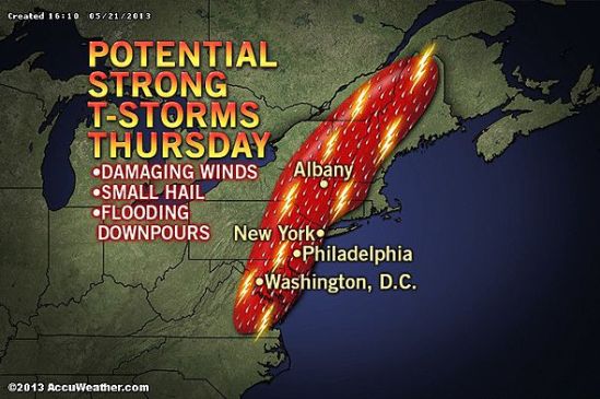
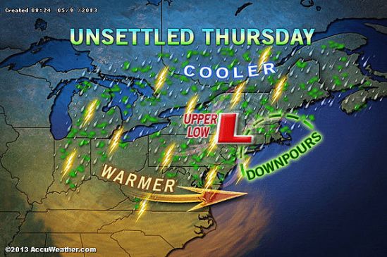
The same storm system responsible for producing violent and deadly thunderstorms in Oklahoma recently will reach the northeast for Thursday. The nature of the storms will change somewhat from producing tornadoes to more of a straight-line wind gust, hail and flash flooding event. However, there is a chance that a couple of the strongest thunderstorms will produce a brief tornado.

The risk for damaging and dangerous thunderstorms is forecast to extend from eastern Virginia to eastern New York state and portions of New England. Much of this area will be in a sea of warm, humid air as a cool front providing a focusing point for the storms arrives.Only the immediate coast of southern and eastern New England would be spared the worst of the gusty storms, due to a flow of cool air off the ocean. People should be prepared for travel problems, sporadic power outages, frequent lightning strikes and urban flooding Thursday afternoon and evening. -SS

Hold off on those beach plans

Hold off on those beach plans

The Memorial Day weekend will begin cool, windy and rainy in New England. The storm system responsible for severe weather and deadly tornadoes over the Plains earlier this week will give birth to a new storm over the Northeast as the week draws to a close and the holiday weekend begins.

The event will start as locally severe thunderstorms Wednesday evening into Thursday evening spreading slowly from the Appalachians to the East Coast. As the storm strengthens, it will cause winds to kick up and will make a pocket of cool air in the region.

Friday night into Saturday could be a flat-out nasty way to start the summer season with a driving wind, rain and temperatures in the 50s and lower 60s in many locations. It might be crazy to think, but it is not entirely out of the question that it gets cold enough for the highest elevations of the Northeast, especially the Adirondacks, Green and White mountains to have wet snowflakes mixing in during the first part of the weekend.

The storm will squeeze out a great deal of moisture from the atmosphere, while drawing additional moisture in from the Atlantic Ocean. The period from Thursday to Sunday bring 4 or more inches of rain to some locations with isolated incidents of flash and urban flooding.

The storm will slowly spin off to the northeast during the second half of the weekend with improving weather conditions and rebounding temperatures. However, portions of New England may hold on to clouds, spotty rain and drizzle through Sunday and possibly into Monday morning-SS
warm day on tap

warm day on tap

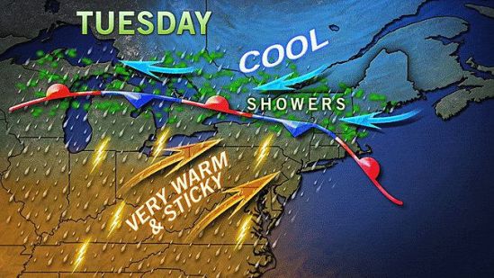
After a day of temperatures near 80 degrees on Monday, the humidity will be kicking up on Tuesday, making it feel sticky across the area. The temps should be warm again, making their way into lower 80s. With just a chance of isolated storms tomorrow, the real threat for storms, doesn’t really arrive until Thursday. -SS

Enjoy today! Storms tonight to tomorrow

Enjoy today! Storms tonight to tomorrow

There is the potential for locally gusty thunderstorms to affect portions of Ohio, Pennsylvania, West Virginia, Maryland, Virginia and upstate New York Friday and Friday night and then areas farther east on Saturday.

The storms will bring a risk of damaging wind gusts, hail, blinding downpours and flash flooding to a few locations. A disturbance will track east-northeastward from the Midwest, along a slowly advancing cool front. The disturbance will raise the intensity of thunderstorms along the frontal zone.

During Saturday, the risk of locally damaging thunderstorms will shift to part of the I-95 corridor from Raleigh, N.C., to Washington, D.C., Philadelphia and New York City. In areas that have received heavy rain recently, there is an elevated risk of flash and small stream flooding. Stay safe and Happy mother’s Day! -SS

Frost possible Monday night

Frost possible Monday night

There is a chance that yet another cold wave slated for the middle of May could have just the right conditions for frost in parts of the Midwest and Northeast.

The period for potential frost would span Sunday to Monday (May 12-13) over part of the Midwest and would settle eastward Monday to Tuesday (May 13-14).

The concern would be for blossoming fruit trees, berry bushes and emerging tender growth as well as flowers and vegetable plants that home gardening enthusiasts may have put out.The frost in this case is mostly likely to occur only during one night in most locations. Be sure to cover and protect any tender vegetation. -SS

Showers again today

Showers again today

Bands of heavy rain and thunderstorms will spiral around a slow-moving, land-based storm over the mid-Atlantic.

It is the same storm which brought record May snowfall to parts of the Plains last week and flooding over the past weekend to portions of the Midwest and South.

The rain bands will shift around with time and breaks of sunshine are possible in between. The storm can produce a couple of inches of rain locally over a several-hour period, which is more than enough to cause flooding problems and travel delays. This was the case around New York City on Wednesday, where over three inches of rain fell in a relatively short amount of time.
-SS

Pollen forecast

Pollen forecast

I’m posting this for all you suffering people out there! The weather pattern looks like it will finally be changing, with some showers and cooler weather moving in this week. The showers will help to wash away a good amount of pollen that has been building up over the last couple weeks. As you can see the forecast for pollen is very high today and tomorrow, but by midweek it will come down a little bit to moderate levels. While not out of the woods yet, some relief is in sight! Keep sneezing! -SS