More storms rolling through

More storms rolling through

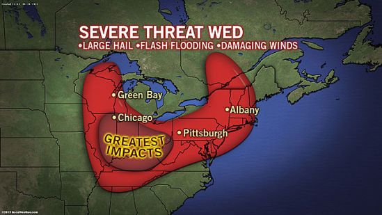
Another show in a seemingly endless parade of severe weather will march through the Midwest into the Northeast on Wednesday, bringing damaging winds, large hail, flash flooding and even the threat for tornadoes along with it. The worst of the storms will produce damaging wind gusts as high as 70 mph, hail as large as golf balls and perhaps an isolated tornado. Wind gusts to 70 mph can easily uproot trees, snap off large branches and bring down power lines. Sporadic power outages are possible in some areas. Winds of this strength can also damage roofs and send unsecured objects airborne. Hail as large as golf balls can cause damage to vehicles and crops. Any people or livestock caught outside can easily be injured. -SS

More flooding rains for Monday

More flooding rains for Monday

Flooding downpours will return to the Northeast on Monday, targeting areas just hit by Andrea.
Numerous showers and thunderstorms will move into the interior Northeast by Monday morning before advancing toward the coast into the evening.
The wet weather is in response to an advancing storm fueled by humid air. Andrea shattered June rainfall records late last week across southern New England. This will make the region extremely vulnerable to flooding on Monday as downpours return. Numerous downpours will extend into the region by the evening commute and can quickly flood small streams and overtake storm drains in the region. Ponding on roadways will be widespread in the region, particularly in urban areas. Don’t drive through water covered roads out there! Stay safe! -SS

Strong storms Sunday

Strong storms Sunday

A widespread area from the northeast to the mid-atlantic should be on the lookout for strong to potentially severe storms on Sunday. Damaging winds and flooding downpours are the main threats from the strongest thunderstorms, which will generally be confined to the afternoon and evening hours. If any tornado touches down, it would be an isolated event.

As the weekend comes to an end, so will the threat for severe weather across the Northeast. Showers and less-intense thunderstorms will linger along the I-95 corridor on Monday as cooler and less humid air moves in behind the storms. -SS