
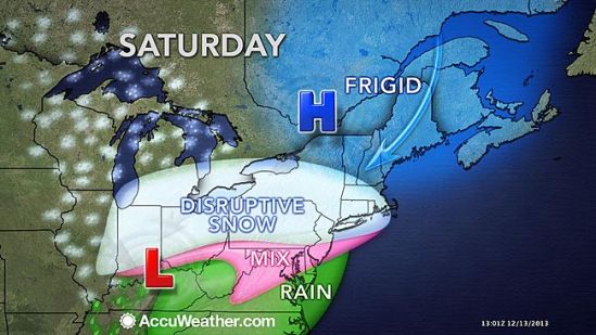
A storm will roll into Connecticut during Saturday, spreading snow and travel delays across the state. While some warmer air will move up with that storm, odds favor an extended period of snow into part of Sunday over much of the state. Accumulations will range from 1 to 3 inches in the southeastern corner of the state, where a change to sleet and rain is likely to around a foot in some northern and western communities, where all snow occurs. In New Haven, we can expect some flurries and snow showers starting around midday, and some heavier snow rolling in between 3 and 4pm. The snow should be steady into the evening hours, but as the storm moves in overnight, the warmer air will be brought up with it and the coast will go to an icy mix of sleet and freezing rain. Some coastal areas will even change to plain rain by Sunday morning. All said and done New Haven should expect 4-8 inches in total from this storm. You won’t have to go too far inland though, to find totals ranging 8-12 inches where the precipitation will stay as all snow. The storm will depart the area Sunday afternoon. Wet and slushy areas will freeze Sunday night, so be alert for areas of black ice. -SS
