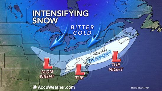
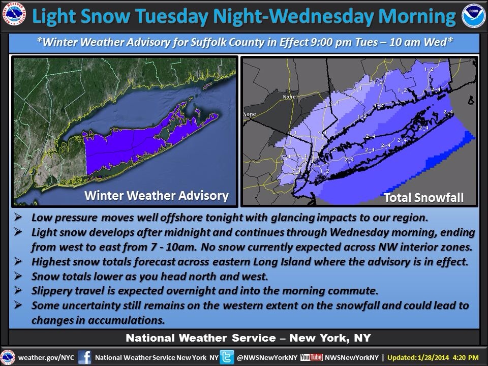
I started watching this storm about a week ago, when It looked like it had the potential to be an all out blizzard for us here in the northeast. As it got closer though, computer models started to come into agreement that it would in fact not crush the northeast. It started to look like it would just roll off the southeast coast and straight out to sea, and not barrel up the coast and turn into a monster nor’easter. As the storm is now formed, and is currently dropping unprecedented heavy snow and ice on the Deep South all the way to the gulf coast! It now looks like it will in fact give us a glancing blow and drop a quick couple inches across the state tonight. Careful in the morning as roads will be treacherous. There should be some delays out there for all you teachers! Happy Tuesday! -SS
Monthly Archives: January 2014
Nor’easter looming!!
All the ingredients are still in place for this potential monster snowstorm for today into tonight. Snow should start between 12-3 from southwest to northeast across the state. It will be getting heavy by later In the afternoon. Probably by 5 or 6 it will be dumping. Head home early from work or take it slow and steady if you must be on the road. New haven should see around 10 inches!! It will be very cold and blustery tonight! Cover up when heading out!! Leave a blanket and or emergency supplies In your car tonight if you must travel tonight. Enjoy the storm!! Gonna be a beauty!!! -SS
Tuesday Snowstorm taking shape!!

All the ingredients are coming together to bring us a potent storm for Tuesday afternoon into Tuesday night. As a cold front moves through the area today ushering in another arctic blast, it will be setting the stage for a coastal storm tomorrow. As the front drops south through the region, a weak Albert Clipper will swoop down out of Canada and ride along this front. When this storm makes contact with the warmer Atlantic waters, it will blossom into an all out southern New England snowstorm. Winter Storm Warnings have just been posted for New Haven for heavy snow accumulating 6-10 inches! This snow will accumulate rapidly as it will be brutally cold. This allows for a greater snow ratio. Usually we get about ten inches of snow for every inch of rain , but as it will only be around 10-20 degrees tomorrow and tomorrow night, we will be getting more like 20-30 inches of snow for every inch of rain.
Snow should invade the area around 3pm tomorrow. It will get heavier and steadier heading into the evening. It is going to be very windy and wind chills will be below zero Tuesday night. Plan ahead and be careful if you have to be out tomorrow night! Lots more to come with this developing storm! Stay tuned! -SS

