Another Tuesday storm

Another Tuesday storm

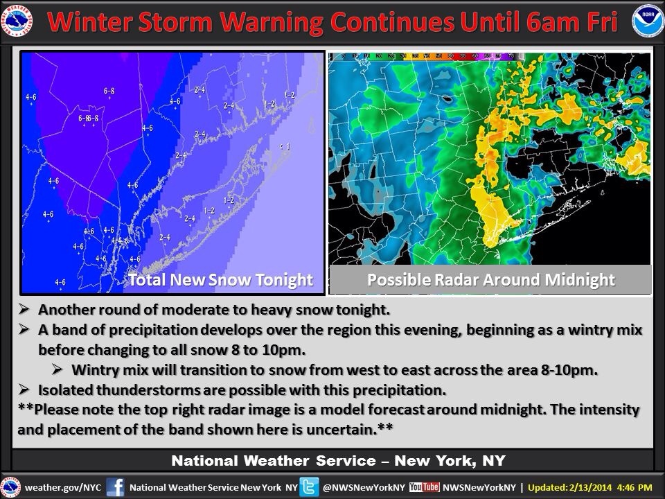
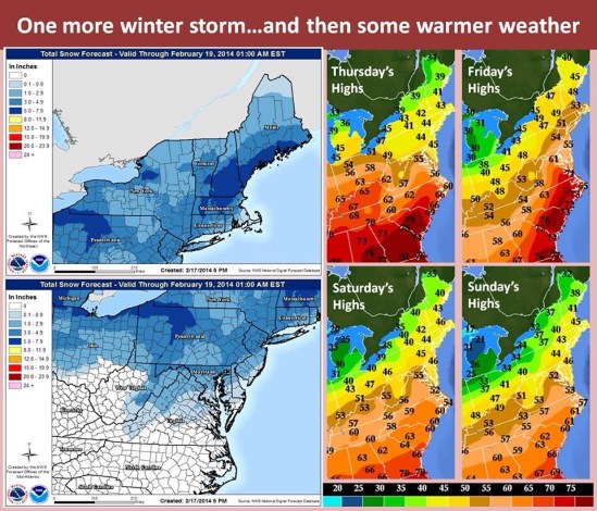
Another Tuesday, another storm! Here we go again, it feels like Groundhog Day. A storm will move out of the Midwest and into the northeast during the day on Tuesday. Snow will start by about 6 or 7 am for the western part of the state and it will work it’s way east. Snow will get heavy by late morning, and it will continue into the afternoon. Temperatures will slowly rise above freezing by the afternoon, and the snow may mix with or change to rain right along the coast. Most areas should expect 2-4 inches of snow, with the highest amounts inland where they can expect 4-5 inches. It should all be done by the mid-late afternoon. This storm also brings with it some good news, as it will usher in some warmer weather for the rest of the week! Highs will approach 50 for most places on Friday! Don’t get too excited though as temperatures will drop back down to seasonal levels by the start of next week. -SS

Second feature moving through tonight!

20140213-183008.jpg

Welp I hope everyone enjoyed the sweet first half of this storm! A general 9-12 inches has already fallen throughout the area, with another 2-4 expected tonight. The worst is over, but it could still be pretty bad tonight when the heavy bands of snow move back through along with some gusty winds! This monster storm is rolling by to the east tonight, and as it moves away it will wrap back around a good size batch of moisture through the area.
Here in southern CT, a light wintry mix will continue through the evening hours. By 8-10 pm the precip should change back over to all snow and pick up in intensity. Everything should be done by sunrise Friday morning. It looks like there will be a whole lot of delays for schools tomorrow, and even some closings.
I hate to mention it now, but it looks like another storm will move through the area during the day on Saturday, dropping a light 1-3 inch snowfall! I’ll keep you all posted! -SS

Monster Nor’easter for late tonight into Thursday

Monster Nor'easter for late tonight into Thursday

A storm bringing heavy ice and snow to the interior Southeast will reach the Northeast Wednesday night and Thursday with heavy snow and gusty winds. This is a very strong and complex storm! As I write this the storm is dropping a historic ice storm on much of the southeast US! Conditions could be catastrophic down there with hundreds of thousands of people without power. As the storm moves up the eastern seaboard today and tonight it will interact and ‘phase’ with an upper level low pressure system that’s moving out of the mid-west. As these storms phase together and combine their powers to form a super-storm nor’easter, it will create my all time favorite weather term… Bombogenesis!! This means the storm will ‘bomb out’ or rapidly strengthen and intensify as it heads up the northeast coast. This will make for potentially the biggest storm of the year for some parts of the mid Atlantic and northeast. As it moves up the coast the exact track is the key here as a subtle shift of 40-50 miles in storm track could mean the difference between just a couple of inches of snow to well over a foot.
The way it looks now, New Haven can expect 6-10 inches before mixing with and changing to freezing rain and sleet and depending on the exact track, even plain rain in the afternoon tommorow. Even if it does change over, all areas will go back to all snow before ending
Thursday night! Inland CT and MA can expect over a foot with the potential for 14-18 inches where it will stay all snow.
The snow should start in the New Haven area around 2 or 3 am overnight Wednesday into Thursday morning. It will become very heavy in the morning and travel will be very treacherous if not impossible.
The big winner here as it looks now (all could change depending on storm track) will be northwestern CT, western MA, southern VT and NH, and heading northeast into Maine. All schools in CT and across NE should be closed tomorrow. Enjoy your snow day kids and teachers. I will update again tonight as the storm approaches and confidence increases on the exact storm track! -SS

It’s go time !

20140204-212921.jpg

Sorry I have been quiet all but I am in Vermont preparing to shred this beast! Winter is finally rearing her beautiful face and she is ready to rip. Right on the heels of the early week storm, comes another behemoth. We also have a potentially bigger storm for the end of the weekend!

Dealing with this current monster is fun, because this looks like a real good chance for widespread 1ft + snowfall for most of the northeast. Not so much in CT, but still a significant storm none the less. Parts of CT should see a foot or more, but that will be confined to the northern half of the state. Especially in the northwest hills where there could be over a foot! Along the coast there should be 3-6 inches of snow with a nice sleet layer and then up to a quarter inch of freezing rain on top.

All precip should start pre-dawn and should be very heavy through the morning hours. With Snowfall rates of an inch an hour or more in some places! The snow will stay falling heavy at times in the inland, but along the coast it will mix with and change to freezing rain and sleet. In some warmer spots right on the coast, it will be just warm enough for it to go to all rain. All precip should be done by the evening hours from west to east.

This is not going to be a very long duration event, but the precip will be very heavy much of the time. Exercise extreme caution if you have to be out tomorrow. Take it slow on the roads.

More to come on this weekend storm and don’t look now but there is even a valentines day storm in the works! More to come! -SS