A Boom or Bust kind of Storm

650x366_01271205_hd22-3

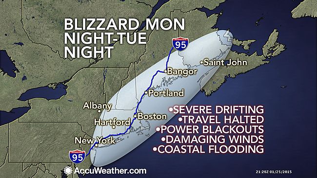
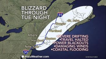
Alright everybody, before you go calling for all the meteorologists heads lets talk about what actually happened. First of all I do agree that there was a ton of hype just like there always is, but it doesn’t take much for forecasts to change as storms happen. This storm as it formed, ended up getting its act together about 50-100 miles east of where it was predicted to do so. Thus, keeping the super heavy snow bands confined solely to eastern New England. In my forecast I called for a widespread 1-2 feet, which is spot on, but we will just be on the low-end of it. I also said there will be an area that gets 30 inches or even as much as 40 inches. This will also still happen somewhere in eastern New England. Probably somewhere in Eastern Mass will come in with the big winner. Shrewsbury, MA is coming through with the most so far, right around 30 inches. The winds also have been as forecast, with gusts  blowing 40-50 mph throughout the entire area. Also, like i stated the Cape an islands have been getting hammered with stronger gusts. On the Vineyard a gust of 78 mph was recorded, which is above hurricane force! Also, currently the entire island of Nantucket is without power.

So while here in most of western Connecticut, this feels like a big bust, It actually will be spot on with my forecast. I agree that meteorologists and news people alike tend to hype big storms, and in turn clean out grocery stores. There is some good reason to this, as people need to heed warnings and prepare for the worst case scenario. As it turns out, the worst case scenario has not come to fruition, and this is a good thing so people will not have as big a cleanup and life can return to normal sooner than first thought. Everybody enjoy your snow day, and stop hating on the weather service. Stay classy! -SS

Steviestorms is coming in hot!

weather

I tried to write this earlier tonight, but had a crash and lost the whole thing… so here goes again…

A monster blizzard is poised to cripple the entire area. A clipper system will move out of the midwest and into the mid-Atlantic on Monday. It will then slide off the coast, strengthen rapidly and head towards the northeast. Everyone in the area should prepare for a potentially ‘historic’ storm. Snow showers will arrive in the morning on Monday, transitioning to light snow in the afternoon, and eventually an all out full fledged blizzard into the overnight. This storm could be the biggest of the year, and maybe even biggest ever in some places. There is an obscenely large swath of 1-2 foot snowfall from NYC through Maine. There will even be a bullseye of snow somewhere in southern New England that wins the medal and gets 2-3 feet!! There could be a big winner out there with 40 inches or more!! Unlike last storm, the cold air is in place so the precipitation will be all snow. It will also be quite cold so the snow to liquid ratio will be anywhere from 15:1 to 20:1. The average is usually around 10:1. (inches of snow from one inch of rain) The other aspect of this storm will be the intense winds. With sustained winds of 25-30 mph, and gusts to 60 mph, this will yield drifts of 4-6 feet! Gusts out on the cape could even top hurricane force! These strong winds off of the water will also create some minor to moderate coastal flooding along the entire coastline. During the height of this storm on Monday night, travel of any sort is discouraged as it will be nearly impossible. It will be so bad that all traffic will be halted for a time. Many roadways will be impassable for hours if not days after the storm ends. Power outages are also possible due to the heavy snow and strong winds. Conditions will improve by Wednesday, allowing crews to begin the clean-up process in the wake of this monster storm. Dry conditions wont last long though, as another clipper system will move through Thursday night into Friday. It could drop a few more inches on us as it slides by. Lastly, the storm has the chance to deliver one of my favorite weather phenomenon of all time….. THUNDERSNOW!!!!! This storm is so intense, that some of the snow bands tomorrow night could produce thunder and lightning that will accompany the falling snow. This is going to be a good one! Saddle up people! -SS