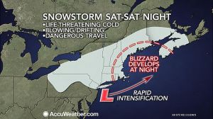
A storm passing through the Northeast this Valentine’s Day weekend is riding a tidal wave of frigid air and will evolve into a blizzard over New England before departing on Sunday. The worst of the storm will target the eastern New England coast Saturday night into Sunday with wind-driven snow. However, high winds, fierce cold and some snow will reach back through CT and southern New England. There will be an arctic front associated with the storm on Saturday night. The arctic front will behave like a squall line, but instead of bringing heavy rain, it could bring a brief period of heavy snow with perhaps thunder and lightning. As the storm moves off the New England coast it will strengthen rapidly and deliver blizzard conditions from eastern Massachusetts, Rhode Island and eastern Connecticut to southeastern New Hampshire, and coastal Maine. On Saturday, as snow squalls roll across the mid-Atlantic and western New England, the storm will start off on a tranquil note. While winds will remain light during the day Saturday, snow will spread over much of the region and pick up the pace in the afternoon in western areas. During Saturday night, increasing wind, plunging temperatures and heavier snow will lead to dangerous travel for the entire area. On Sunday, snow and blizzard conditions will continue in New England for a time as even colder air empties into the region. Strong wind gusts will continue to make for dangerously low wind chills, and the chance for power outages. When it’s all said and done, southern CT should expect a general wind-blown 4-8 inches of snow, but I won’t be surprised if there are some 10-12 inch totals especially in eastern areas. Stay warm and stay safe! -SS
Monthly Archives: February 2015
Another round of snow and ice heading in
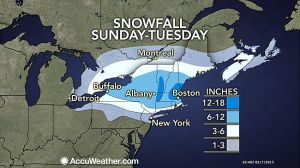
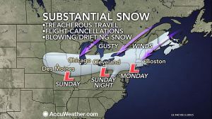
As the last storm in this series of storms heads in, It will be the strongest of the bunch. This storm will feature a wide range of snow and ice totals. With the heaviest falling from northern CT on northward. There will be a swath near Boston and southern Vt that could see up to 2 feet! There will be a general 8-12 for most of the northeast, with the exception of southern coastal CT that gets only 3-6 because of some mixing and changing to sleet and freezing rain on Sunday night, before changing to all snow on Monday morning. The bulk of the snow should be gone by Monday night, but some lingering snow showers should stick around until Tuesday for the mountains of northern New England. There is another chance for some snow on Thursday, and that storm will be followed by the coldest air of the season. Stay tuned! -SS
Ground Hog Day Storm!
Here we go again! Where is Bill Murray when you need him? There is a very large storm sweeping out of the midwest and heading into our area overnight tonight. It should arrive sometime around the end of the big game. This will be a rough scenario for all the people trying to make it home after the game. The storm is strengthening as it gathers moisture from the Pacific Ocean, Gulf of Mexico, and eventually the Atlantic ocean. The snow will be heavy tonight with accumulating snow through the night on the order of 5-8 inches. Even though temps will be cold in the 20s, this storm will be deepening and moving just to our south, this will in turn change our precipitation to sleet and freezing rain in the morning. This will create a very dangerous situation for the morning commute, as there can be significant icing in some places. As the storm moves away, it will drag down very cold air in behind it, and change it back to all snow by the afternoon We could see another 2-4 inches of snow and ice tomorrow, bringing our storm total to 8-12 inches. This number could be a little higher inland where it could stay all snow, or only ice for a short period of time. Also, along the immediate coast it could ice for a longer period, therefore allowing for lesser snow totals. The temperatures will drop rapidly tomorrow night to around 0 degrees. This will create a flash freeze, in turn freezing any slush and standing water very rapidly. This storm is poised to drop a huge swath of snow across a large area. It will create very a hazardous and deteriorating condition throughout the entire region. Leave extra time in the morning if you must travel, and if it does go to freezing rain and sleet, travel will be nearly impossible. There will also be some snow showers in the area for Wednesday and Thursday, and it is far away but it looks like a ground hog day scenario as we are watching another storm for next Monday! It is far away, but it is something to watch. Stay classy and enjoy the Super Bowl! -SS


