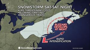
A storm passing through the Northeast this Valentine’s Day weekend is riding a tidal wave of frigid air and will evolve into a blizzard over New England before departing on Sunday. The worst of the storm will target the eastern New England coast Saturday night into Sunday with wind-driven snow. However, high winds, fierce cold and some snow will reach back through CT and southern New England. There will be an arctic front associated with the storm on Saturday night. The arctic front will behave like a squall line, but instead of bringing heavy rain, it could bring a brief period of heavy snow with perhaps thunder and lightning. As the storm moves off the New England coast it will strengthen rapidly and deliver blizzard conditions from eastern Massachusetts, Rhode Island and eastern Connecticut to southeastern New Hampshire, and coastal Maine. On Saturday, as snow squalls roll across the mid-Atlantic and western New England, the storm will start off on a tranquil note. While winds will remain light during the day Saturday, snow will spread over much of the region and pick up the pace in the afternoon in western areas. During Saturday night, increasing wind, plunging temperatures and heavier snow will lead to dangerous travel for the entire area. On Sunday, snow and blizzard conditions will continue in New England for a time as even colder air empties into the region. Strong wind gusts will continue to make for dangerously low wind chills, and the chance for power outages. When it’s all said and done, southern CT should expect a general wind-blown 4-8 inches of snow, but I won’t be surprised if there are some 10-12 inch totals especially in eastern areas. Stay warm and stay safe! -SS

