Glancing blow tonight into tomorrow

20140128-165458.jpg

I started watching this storm about a week ago, when It looked like it had the potential to be an all out blizzard for us here in the northeast. As it got closer though, computer models started to come into agreement that it would in fact not crush the northeast. It started to look like it would just roll off the southeast coast and straight out to sea, and not barrel up the coast and turn into a monster nor’easter. As the storm is now formed, and is currently dropping unprecedented heavy snow and ice on the Deep South all the way to the gulf coast! It now looks like it will in fact give us a glancing blow and drop a quick couple inches across the state tonight. Careful in the morning as roads will be treacherous. There should be some delays out there for all you teachers! Happy Tuesday! -SS

Nor’easter looming!!

20140121-092052.jpg

All the ingredients are still in place for this potential monster snowstorm for today into tonight. Snow should start between 12-3 from southwest to northeast across the state. It will be getting heavy by later In the afternoon. Probably by 5 or 6 it will be dumping. Head home early from work or take it slow and steady if you must be on the road. New haven should see around 10 inches!! It will be very cold and blustery tonight! Cover up when heading out!! Leave a blanket and or emergency supplies In your car tonight if you must travel tonight. Enjoy the storm!! Gonna be a beauty!!! -SS

Tuesday Snowstorm taking shape!!

Tuesday Snowstorm taking shape!!

All the ingredients are coming together to bring us a potent storm for Tuesday afternoon into Tuesday night. As a cold front moves through the area today ushering in another arctic blast, it will be setting the stage for a coastal storm tomorrow. As the front drops south through the region, a weak Albert Clipper will swoop down out of Canada and ride along this front. When this storm makes contact with the warmer Atlantic waters, it will blossom into an all out southern New England snowstorm. Winter Storm Warnings have just been posted for New Haven for heavy snow accumulating 6-10 inches! This snow will accumulate rapidly as it will be brutally cold. This allows for a greater snow ratio. Usually we get about ten inches of snow for every inch of rain , but as it will only be around 10-20 degrees tomorrow and tomorrow night, we will be getting more like 20-30 inches of snow for every inch of rain.

Snow should invade the area around 3pm tomorrow. It will get heavier and steadier heading into the evening. It is going to be very windy and wind chills will be below zero Tuesday night. Plan ahead and be careful if you have to be out tomorrow night! Lots more to come with this developing storm! Stay tuned! -SS

Potential Major Winter Storm Thursday into Friday!!

Potential Major Winter Storm Thursday into Friday!!

Two storms will converge on the Northeast on Thursday with the potential for snow. How quickly they get together and strengthen will determine which areas are hit with heavy snow and which areas will have a near-miss. The snowier of two scenarios would suggest that New England will be hit with a powerful nor’easter that produces blizzard conditions, damaging winds and coastal flooding!! Even if the two Thursday storms are slow to converge, they should still wrap enough moisture around to produce a snowstorm over New England. This storm is a couple days away from coming together, and I will do my best to keep you informed of this potential monster nor’easter! -SS

2-4 inch snowfall today!

2-4 inch snowfall today!

A new system started in the Midwest Monday, but tracks into the Northeast today. It is an Alberta clipper, meaning the storm originates from Alberta, Canada. Usually these systems are very weak, and don’t drop a lot of snow, but this one is a little different. This storm is going to transfer it’s energy to a newly forming coastal low, and drop a widespread light to moderate snow accumulation. By the time this storm really gets going, it will already be moving away from the coast of New England, and it will be moving too fast to really unleash its full fury on the northeast. Here in Connecticut, the snow will start around 8 or 9 am an last until 4 or 5 pm. it will be a tough call for schools, because of the start times, but i imagine there will be a good amount of closings and early dismissals around the state. Drive safe and take it slow out there! -SS

Good looking storm for tomorrow!!

Good looking storm for tomorrow!!

A storm will roll into Connecticut during Saturday, spreading snow and travel delays across the state. While some warmer air will move up with that storm, odds favor an extended period of snow into part of Sunday over much of the state. Accumulations will range from 1 to 3 inches in the southeastern corner of the state, where a change to sleet and rain is likely to around a foot in some northern and western communities, where all snow occurs. In New Haven, we can expect some flurries and snow showers starting around midday, and some heavier snow rolling in between 3 and 4pm. The snow should be steady into the evening hours, but as the storm moves in overnight, the warmer air will be brought up with it and the coast will go to an icy mix of sleet and freezing rain. Some coastal areas will even change to plain rain by Sunday morning. All said and done New Haven should expect 4-8 inches in total from this storm. You won’t have to go too far inland though, to find totals ranging 8-12 inches where the precipitation will stay as all snow. The storm will depart the area Sunday afternoon. Wet and slushy areas will freeze Sunday night, so be alert for areas of black ice. -SS

Watching another storm for the upcoming weekend

Watching another storm for the upcoming weekend

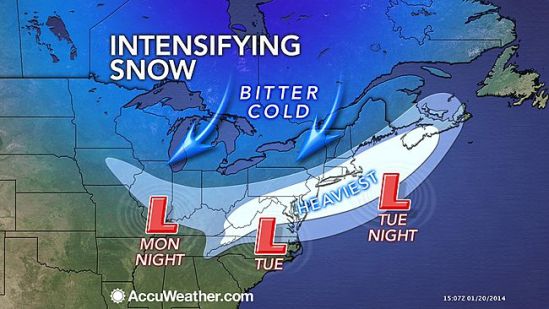
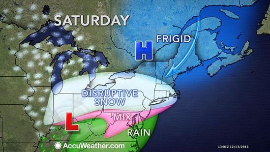
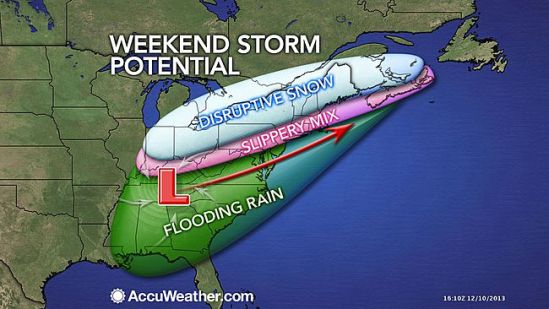
The punches just keep on coming from Old Man Winter with a new storm poised to impact parts of the South, Midwest and Northeast this weekend, threatening to bring travel delays and disruptions to outdoor activities. The storm will affect the Central states Friday night into Saturday and much of the East Saturday into Sunday.

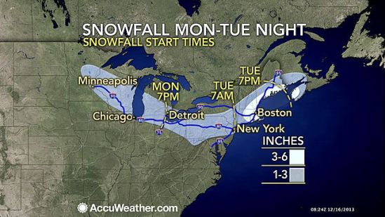
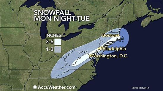
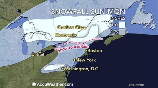
A stripe of heavy snow is most likely to fall over parts of northern Indiana, Ohio and northwestern Pennsylvania, upstate New York, northern New England and neighboring Canada. Cities that could be hit with an all-out snowstorm include Cleveland, Syracuse, N.Y., and Burlington, Vt. Most cities in the I-95 corridor of the Northeast will have a brief period of snow or a wintry mix at the onset, followed by rain at the height of the storm. A change to plain rain is forecast in Washington, D.C., Philadelphia, New York City and Boston. However, it could snow hard prior to a change to rain in part of the coastal Northeast, raising concerns for a period of slippery travel.

The storm will come together over the Deep South Friday and head toward a cold high pressure system moving across the Northeast. The storm will be preceded by the coldest air of the season so far in parts of the Midwest and Northeast. The storm itself will attack the cold air, removing much of it, but squeezing out heavy precipitation in the process.

In the wake of the storm this weekend, a mixture of Arctic and Pacific air is forecast to come in, so it may not feel quite as cold as recent days from the Midwest to the East. The milder air starting next week will allow a break from the wintry precipitation in some areas hit hard, but not everywhere. Just enough cold air will linger in the northern tier states to allow more storms with snow and wintry mix as the the month progresses. -SS

More wintry weather for Tuesday

More wintry weather for Tuesday

The Northeast will have another round of accumulating snowfall early this week, right on the heels of the weekend winter storm. Most locations will pick up 1 to 3 inches of snow from this storm. However, the worst of the snow looks to fall across the I-95 corridor with 3 to 6 inches of snow in the forecast for cities such as New York, Philadelphia, Washington, D.C., Boston and Baltimore. Unlike the storm this past weekend that brought a combination of snow, sleet and freezing rain to the region, precipitation looks to fall mainly as snow in the Northeast with rain farther to the south. Snow will come to an end on Tuesday night across the region as the storm quickly tracks off the East Coast. -SS

Little wintry weather tonight

Little wintry weather tonight

A potent winter storm will continue to spread an icy mix from the Ohio Valley to the mid-Atlantic and Northeast through the remainder of the weekend. The icy mix and freezing drizzle are making travel treacherous. Enough freezing rain threatens to coat parts of the Ohio Valley, mid-Atlantic and Northeast for some power outages and tree damage.

Here in southern CT, we can expect some light snow to begin by sunset tonight. That snow will slowly transition to a wintry mix into the overnight. By daybreak, coastal communities will go to just plain rain, while inland areas may stay as some wintry mix or even freezing rain and icing conditions. There will a general slushy snow and ice accumulation of 1-3 inches throughout the area.

Everybody should expect a very sloppy morning commute, with school delays and even closings possible. Take it slow and don’t drive if you don’t have to! It will be treacherous through the overnight! -SS

Watching coastal storm for biggest travel day of year!

Watching coastal storm for biggest travel day of year!

All eyes are now on the potential winter storm for midweek next week. This is a tough time for a big storm, as this is one of the biggest travel times of the year.

The painful blast of wind-driven Arctic air set to invade the Plains this week and East this weekend will fade in most areas while a storm sinking southward in the West will slowly move east. The speed at which this storm moves along and how sharp of a left turn the storm takes later next week is uncertain.

For most areas along the East Coast and South, it will be a question of rain or not on Tuesday, Wednesday and Thanksgiving Day. Rain, poor visibility and low ceilings alone on Wednesday can lead to its share of major delays.

However, just enough chilly air may be in place beginning around the central Appalachians northward to New England for snow and ice, depending on the track, strength and timing of that Gulf Coast storm, which is likely to become an Atlantic coast storm.

Early indications are the storm would swing northeastward across the Appalachians and I-95 corridors later Tuesday, Wednesday into Wednesday night. Details as to when and where the storm will have the most impact will unfold later this week into this weekend.

I’ll keep everyone posted as this storm comes together and takes shape! -SS