Imminent Destruction in the Philippines from Super Typhoon Haiyan

Imminent Destruction in the Philippines from Super Typhoon Haiyan

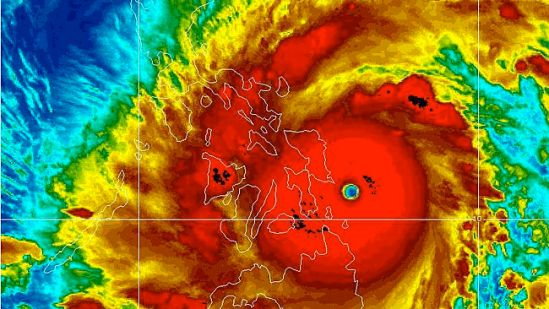
Super Typhoon Haiyan (local name Yolanda) is bringing a significant risk to lives and property as the monster storm moves across the Philippines. I feel the need to blog about this storm, because of how intense this storm is. It is truly an awesome storm.

On Friday, the sustained winds with this exceptionally dangerous storm increased to 315 kph (195 mph), surpassing the winds of Super Typhoon Lekima, which was previously the strongest tropical system in the world for the 2013 season based on wind speed and central pressure. I can’t even imagine what 200 mph sustained winds are going to do to that part of the world. It’s going to be ugly.

The strength of Haiyan is equal to that of an extremely powerful Category 5 hurricane in the Atlantic.

Widespread torrential rain and damaging winds will accompany Haiyan through the central Philippines, threatening to leave a trail of destruction and triggering life-threatening flash floods.

Rain totals along the path of Haiyan could top 200 mm (8 inches). Mudslides are a serious concern in the higher terrain, where localized totals of 250 to 300 mm (10 to 12 inches) are possible.

Good Luck to everyone in that part of the world, and send some prayers their way as they will need it as they deal with one of the strongest storms we’ve ever seen. -SS

Stevie Storms is back, and so is the chance of snow!

Stevie Storms is back, and so is the chance of snow!

Hello again everybody!! I took a little hiatus from blogging as the weather has been nice and fairly tranquil! With no real tropical threats this year, we finally get a break from the major storms. That doesn’t mean there won’t be snow storms though. As we are now only a couple weeks into the fall, we are already talking about a chance of snow here in the northeast. A cold blast of air, driving into the Eastern states, may set the table for a swath of snow next week from the Ohio Valley to New England.

A few temperature swings are likely through the weekend from the Upper Midwest to the Southeast before a large zone of cold air builds into the area next week.
Although the exact track of a potential storm system and impacts will need to be ironed out over the next several days, it is likely that the coldest air of the season will dive into the Midwest Monday, followed by the Ohio Valley and potentially to us here on the East Coast by midweek.

A few storm scenarios exist. One is that a coastal low develops near the Carolinas and slides up the East Coast, bringing coastal rain, inland snow and gusty winds.

Another possible option is that this low does not make the turn up the coast and slides out to sea instead. This track would favor a rain and snow mix for the central Appalachians with dry, cold conditions in New England.

A third scenario depicts an unusually strong storm that moves up the coast then backs into the Northeast. This type of setup would lead to heavy snow well inland but rain in the big cities of the I-95 corridor.

This storm is still a week away and nothing is certain, but it is something that needs to be watched! Glad to be back and talk to you all soon! -SS

Super crazy oppressive heat

Super crazy oppressive heat

This should be the last day of this ridiculously oppressive heat. With temperatures nearing 100 degrees, and the dew point in the 70s, it is going to feel more like 110 today!! Luckily tomorrow late in the day a cold front should arrive with strong to severe storms! This will get us back to some more normal temps into the 80s. Be safe out there! its dangerously hot out! Please check on elderly and people living alone. Drink lots of water and don’t go outside unless you have to! Also please please please don’t leave any pet or human in a car, even for just a minute as temperatures can get to 140-150 rapidly in this weather! Stay safe and cool! -SS

Severe storms possible

Severe storms possible

As a cold front swings through the region on Wednesday, two very different air masses will collide. The drier air from the northern Plains will meet the steamy air coming from the Southeast into the mid-Atlantic. The merge of dry air and very moist air will create favorable conditions for thunderstorms, some of which may be severe.
The main threats with these storms will be torrential downpours, damaging wind gusts in excess of 60 mph and even some hail. -SS

More storms rolling through

More storms rolling through

Another show in a seemingly endless parade of severe weather will march through the Midwest into the Northeast on Wednesday, bringing damaging winds, large hail, flash flooding and even the threat for tornadoes along with it. The worst of the storms will produce damaging wind gusts as high as 70 mph, hail as large as golf balls and perhaps an isolated tornado. Wind gusts to 70 mph can easily uproot trees, snap off large branches and bring down power lines. Sporadic power outages are possible in some areas. Winds of this strength can also damage roofs and send unsecured objects airborne. Hail as large as golf balls can cause damage to vehicles and crops. Any people or livestock caught outside can easily be injured. -SS

More flooding rains for Monday

More flooding rains for Monday

Flooding downpours will return to the Northeast on Monday, targeting areas just hit by Andrea.
Numerous showers and thunderstorms will move into the interior Northeast by Monday morning before advancing toward the coast into the evening.
The wet weather is in response to an advancing storm fueled by humid air. Andrea shattered June rainfall records late last week across southern New England. This will make the region extremely vulnerable to flooding on Monday as downpours return. Numerous downpours will extend into the region by the evening commute and can quickly flood small streams and overtake storm drains in the region. Ponding on roadways will be widespread in the region, particularly in urban areas. Don’t drive through water covered roads out there! Stay safe! -SS

Strong storms Sunday

Strong storms Sunday

A widespread area from the northeast to the mid-atlantic should be on the lookout for strong to potentially severe storms on Sunday. Damaging winds and flooding downpours are the main threats from the strongest thunderstorms, which will generally be confined to the afternoon and evening hours. If any tornado touches down, it would be an isolated event.

As the weekend comes to an end, so will the threat for severe weather across the Northeast. Showers and less-intense thunderstorms will linger along the I-95 corridor on Monday as cooler and less humid air moves in behind the storms. -SS

Steamy then stormy weekend

Steamy then stormy weekend

During the upcoming weekend, the heat will be chopped down over the Midwest by an advancing zone of thunderstorms associated with a cold front. The storms could be locally severe.

The cold front and storms would reach the Appalachians Saturday night and Sunday then the I-95 corridor by Monday. -SS

The heat is on

The heat is on

Midsummer heat is arriving just a few days after the unofficial start of the season. After shivering cold over the Memorial Day weekend, record-challenging heat will build. Some locations will experience a 50- to 55-degree temperature rise compared to morning lows this past weekend to afternoon highs Thursday to Saturday. -SS