Back and forth temps next week

Back and forth temps next week

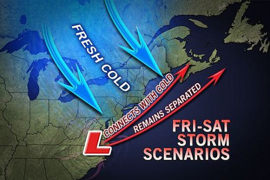
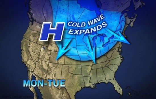
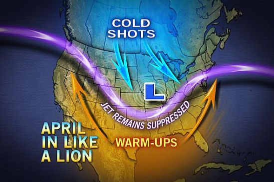
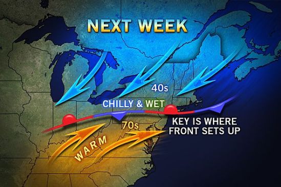
A cold versus warm air battle zone is likely to set up this weekend into next week stretching from the Great Lakes to the Northeast.

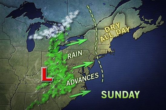
Warmth will build over much of the Eastern states in the wake of the coastal storm for the end of this week. However, there will be some resisting cold air.

A frontal zone is likely to wobble from north to south and back multiple times across the northeastern part of the nation this weekend through next week. Areas south of the front will surge into the 70s during multiple days with sunshine. However, areas north of the front will stay around the 30s and 40s. In some cases, the stubborn chilly air will be accompanied by clouds, rain, fog and drizzle.

The frontal zone could set up near the U.S./Canada border or could set up near the Mason-Dixon line or possibly even farther south. Depending on where it does set up, it could move temps back and forth by as much as 30 degrees. Here’s hoping it sets up to the north of us, and we can finally get into some warmer weather. -SS

Fire weather warning today

Fire weather warning today

A red flag warning has been issued for the entire state today. A red flag warning means that dangerous fire weather conditions are expected due to a combination of gusty winds, very low relative humidity, and very dry fuels. Any fires that do develop can quickly get out of control and spread rapidly.People are advised to not do any outdoor burning today, and to be careful with discarded cigarettes. -SS

Hope on the Horizon

Hope on the Horizon

As the forecast temperature trends come out for the month of April, we can breath a sigh of relief as it looks like we finally break out of old man winter’s grip. Starting in the second week of the month and continuing for the remainder of the month the pattern finally looks to shift from unseasonably cold temperatures to average and even above average temps! So just tough it out for the rest of this week, because by the weekend it looks to be near normal again as we see temps back into the 50s! Summers coming! (Maybe) -SS

Watching Coastal Storm for Friday

Watching Coastal Storm for Friday

Hope everyone is enjoying Spring! At least i think it’s Spring, because it feels like the middle of winter. Along with the cold air, we will have to also watch a coastal storm for the end of the week. If it comes close enough to the coast, there could be lots of heavy wet snow for inland locations, and rain for the coast. As it looks right now, this will not be the case, and the storm will pass us by with just some fringe effects for the region. This is still something to watch, and i will keep you posted. -SS

Nice Easter Sunday

Nice Easter Sunday

The warm weather looks to continue on this holiday weekend. It will be well into the 50s again on Sunday, but there will be an increase of clouds in the afternoon as showers move in. Showers will become more widespread into the overnight, and into Monday morning. Another front will move through the region on Monday, and this will drop temperatures back into the 40s for Tuesday and Wednesday. Keep thinking Spring! It can’t be too far! -SS

Finally seasonable, but not for long

Finally seasonable, but not for long

After a slight warmup this weekend, temperatures are finally up to about average for this time of year. This will change early next week as a couple frontal boundaries move through the area by Monday and into Tuesday. This will chill the air, and in turn cool temperatures to below average levels again by midweek. The cold air usually doesn’t stick around for too long this time of year, and by the end of the week we should be closer to normal. Keep thinking spring! It’s coming! -SS

Tale of two Marches

Tale of two Marches

Finally we are seeing some 50 degree weather! I love how warm it feels right now, but in a month or two 50 degrees will feel freezing!

If we look back to last March though it was a little different. We saw many high temperatures in the 70s and even some 80s! This is remarkable as this year we didn’t even hit 60 degrees!

If you look at the stats for Central Park, this has only happened 9 times in the last 100 years!

As we push forward into April it will stay chilly, but there will be a slow warming trend! We should hopefully push 60 by the first week of the month! -SS

April in like a lion

April in like a lion

It looks like April will be the month to come in like a lion and out like a lamb. With several shots of cold air making their way south this April, it will feel more like March. In a year when March is more like February, it is only fitting for April to be more like March. It will not be as cold as it was in March, but it will be unseasonably cold compared to normal. It looks like it will take until at least mid-April to get temperatures back on track. This doesn’t mean it will be very cold this month, but it does mean we could have more cloudy, rainy, and cooler days than we should have. As Spring progresses and the sun angle changes and gains warmth, the temperatures will in turn get warmer and more seasonable. I hope the groundhog still has a job next year.. -SS

Still on edge

Still on edge

The storm as it looks now, has taken more of a right turn, and will go out to sea. This map still has 1-3 inches for the very immediate coast of Connecticut, but i doubt anyone sees even one inch of snow. This storm will bring nothing more than some mixed rain and snow showers this evening, mainly on the coast. With such a large storm nearby, it will be a little breezy today, and there is a chance for some minor coastal flooding.

On the bright side, the extended forecast is showing no snow at this time, and even a slight warming trend! Stay tuned for spring! -SS

Living on the edge

Living on the edge

Southern Connecticut will be on the northern most edge of this next large winter storm. The track is still not set in stone, and just a little change in track will greatly increase or decrease snowfall! As it looks now, we should only see a slushy inch or two. Snow will start Monday morning and continue through the day. It will mix with rain at times in the afternoon, but into the evening it will change back to all snow. This does not look like a major storm (for us) as it is right now, but it will need to be watched as it could still drop a sneak attack several inches in some places! Keep you posted! -SS