
Hello again everybody!! I took a little hiatus from blogging as the weather has been nice and fairly tranquil! With no real tropical threats this year, we finally get a break from the major storms. That doesn’t mean there won’t be snow storms though. As we are now only a couple weeks into the fall, we are already talking about a chance of snow here in the northeast. A cold blast of air, driving into the Eastern states, may set the table for a swath of snow next week from the Ohio Valley to New England.
A few temperature swings are likely through the weekend from the Upper Midwest to the Southeast before a large zone of cold air builds into the area next week.
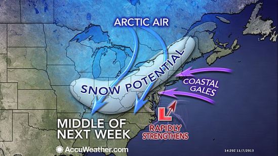
Although the exact track of a potential storm system and impacts will need to be ironed out over the next several days, it is likely that the coldest air of the season will dive into the Midwest Monday, followed by the Ohio Valley and potentially to us here on the East Coast by midweek.
A few storm scenarios exist. One is that a coastal low develops near the Carolinas and slides up the East Coast, bringing coastal rain, inland snow and gusty winds.
Another possible option is that this low does not make the turn up the coast and slides out to sea instead. This track would favor a rain and snow mix for the central Appalachians with dry, cold conditions in New England.
A third scenario depicts an unusually strong storm that moves up the coast then backs into the Northeast. This type of setup would lead to heavy snow well inland but rain in the big cities of the I-95 corridor.
This storm is still a week away and nothing is certain, but it is something that needs to be watched! Glad to be back and talk to you all soon! -SS
