Severe storms possible

Severe storms possible

As a cold front swings through the region on Wednesday, two very different air masses will collide. The drier air from the northern Plains will meet the steamy air coming from the Southeast into the mid-Atlantic. The merge of dry air and very moist air will create favorable conditions for thunderstorms, some of which may be severe.
The main threats with these storms will be torrential downpours, damaging wind gusts in excess of 60 mph and even some hail. -SS

More flooding rains for Monday

More flooding rains for Monday

Flooding downpours will return to the Northeast on Monday, targeting areas just hit by Andrea.
Numerous showers and thunderstorms will move into the interior Northeast by Monday morning before advancing toward the coast into the evening.
The wet weather is in response to an advancing storm fueled by humid air. Andrea shattered June rainfall records late last week across southern New England. This will make the region extremely vulnerable to flooding on Monday as downpours return. Numerous downpours will extend into the region by the evening commute and can quickly flood small streams and overtake storm drains in the region. Ponding on roadways will be widespread in the region, particularly in urban areas. Don’t drive through water covered roads out there! Stay safe! -SS

Strong storms Sunday

Strong storms Sunday

A widespread area from the northeast to the mid-atlantic should be on the lookout for strong to potentially severe storms on Sunday. Damaging winds and flooding downpours are the main threats from the strongest thunderstorms, which will generally be confined to the afternoon and evening hours. If any tornado touches down, it would be an isolated event.

As the weekend comes to an end, so will the threat for severe weather across the Northeast. Showers and less-intense thunderstorms will linger along the I-95 corridor on Monday as cooler and less humid air moves in behind the storms. -SS

Strong storms today!!

Strong storms today!!

The same storm system responsible for producing violent and deadly thunderstorms in Oklahoma recently will reach the northeast for Thursday. The nature of the storms will change somewhat from producing tornadoes to more of a straight-line wind gust, hail and flash flooding event. However, there is a chance that a couple of the strongest thunderstorms will produce a brief tornado.

The risk for damaging and dangerous thunderstorms is forecast to extend from eastern Virginia to eastern New York state and portions of New England. Much of this area will be in a sea of warm, humid air as a cool front providing a focusing point for the storms arrives.Only the immediate coast of southern and eastern New England would be spared the worst of the gusty storms, due to a flow of cool air off the ocean. People should be prepared for travel problems, sporadic power outages, frequent lightning strikes and urban flooding Thursday afternoon and evening. -SS

Hold off on those beach plans

Hold off on those beach plans

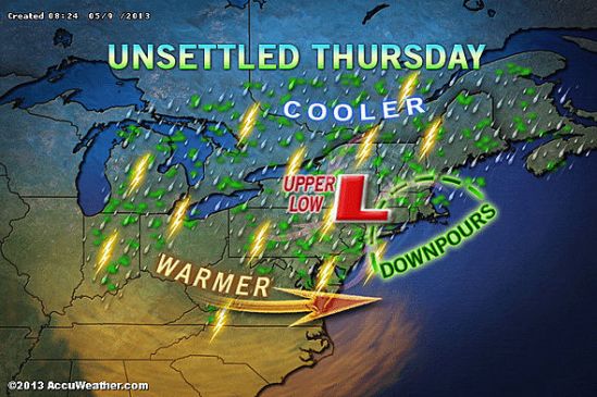
The Memorial Day weekend will begin cool, windy and rainy in New England. The storm system responsible for severe weather and deadly tornadoes over the Plains earlier this week will give birth to a new storm over the Northeast as the week draws to a close and the holiday weekend begins.

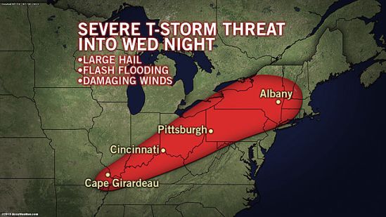
The event will start as locally severe thunderstorms Wednesday evening into Thursday evening spreading slowly from the Appalachians to the East Coast. As the storm strengthens, it will cause winds to kick up and will make a pocket of cool air in the region.

Friday night into Saturday could be a flat-out nasty way to start the summer season with a driving wind, rain and temperatures in the 50s and lower 60s in many locations. It might be crazy to think, but it is not entirely out of the question that it gets cold enough for the highest elevations of the Northeast, especially the Adirondacks, Green and White mountains to have wet snowflakes mixing in during the first part of the weekend.

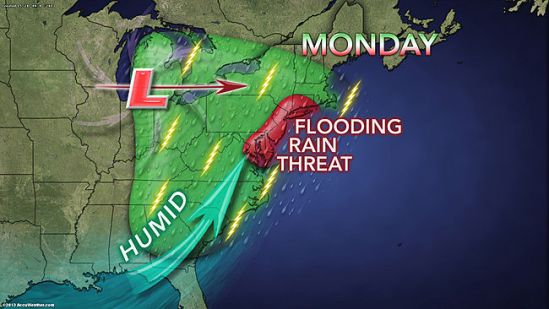
The storm will squeeze out a great deal of moisture from the atmosphere, while drawing additional moisture in from the Atlantic Ocean. The period from Thursday to Sunday bring 4 or more inches of rain to some locations with isolated incidents of flash and urban flooding.

The storm will slowly spin off to the northeast during the second half of the weekend with improving weather conditions and rebounding temperatures. However, portions of New England may hold on to clouds, spotty rain and drizzle through Sunday and possibly into Monday morning-SS

Enjoy today! Storms tonight to tomorrow

Enjoy today! Storms tonight to tomorrow

There is the potential for locally gusty thunderstorms to affect portions of Ohio, Pennsylvania, West Virginia, Maryland, Virginia and upstate New York Friday and Friday night and then areas farther east on Saturday.

The storms will bring a risk of damaging wind gusts, hail, blinding downpours and flash flooding to a few locations. A disturbance will track east-northeastward from the Midwest, along a slowly advancing cool front. The disturbance will raise the intensity of thunderstorms along the frontal zone.

During Saturday, the risk of locally damaging thunderstorms will shift to part of the I-95 corridor from Raleigh, N.C., to Washington, D.C., Philadelphia and New York City. In areas that have received heavy rain recently, there is an elevated risk of flash and small stream flooding. Stay safe and Happy mother’s Day! -SS

Showers again today

Showers again today

Bands of heavy rain and thunderstorms will spiral around a slow-moving, land-based storm over the mid-Atlantic.

It is the same storm which brought record May snowfall to parts of the Plains last week and flooding over the past weekend to portions of the Midwest and South.

The rain bands will shift around with time and breaks of sunshine are possible in between. The storm can produce a couple of inches of rain locally over a several-hour period, which is more than enough to cause flooding problems and travel delays. This was the case around New York City on Wednesday, where over three inches of rain fell in a relatively short amount of time.
-SS

Slop ending as rain today

Slop ending as rain today

As predicted, we got a few inches of snow last night. Overnight as warmer air moved in and temperatures rose above freezing, the snow transitioned to freezing rain, sleet, and finally rain. The rain will taper off to showers later on this evening. Be careful when venturing out as there might still be some slick spots on untreated side roads and sidewalks. Temperatures in a few inland spots are still below freezing, and icing conditions can still exist. Take it slow out there! Off to VT for me to enjoy this fresh powder on the slopes! -SS

HERE WE GO

HERE WE GO

I’m not even sure where to start with this today!! All the ingredients are coming together to make this a monster storm. This storm will begin to move into the area tonight with snow for all locations. The snow will continue into the overnight, but this is where it gets tricky. As this storm moves in, it is going to transfer its energy to a new storm which will develop off of the New Jersey coast and move to the north or northeast.

This is going to be a tough one to call, when the new storm forms and then strengthens, so will the east and northeast winds. They will usher in lots of moisture, but also some warmer air aloft. The warm air will fill in the upper levels of the atmosphere, but not at the surface. This will lead to a prolonged period of sleet and freezing rain. This could fall heavy at times late tonight into Tuesday morning. This will be a tough one for accumulations, but it now looks like a general 3-5 inches all the way to New Haven. There will be some higher elevations in the hills of Connecticut that see 6-10 inches. If you go north from there into northern New England, they will be measuring in FEET of snow. With the ice, some of the valleys in southern Connecticut could be stuck just at or below freezing therefore extending the icing period into the morning. Use extreme caution in icy conditions, as 4 wheel drive does not help with braking on icy surfaces. There will be an accumulation of ice and sleet on top of the fallen snow which will make for extremely dangerous conditions.

This is a very potent storm that needs to be watched closely. The end of the afternoon commute tonight could get sloppy, but the main concern will be the Tuesday morning commute. Expect numerous school closings and delays for Tuesday. More to come! -SS

Projected snow map

Projected snow map

Well here comes another big complex storm into the area for Monday night into Tuesday. Inland portions of the northeast could see well over a foot from this storm!! Closer to the coast of Connecticut, we should only see a slushy inch or two before it mixes and changes to rain on Tuesday morning. This is going to have to be watched closely as some spots might hang close to the freezing mark early Tuesday, and there could be a prolonged period of freezing rain.

This will heavily impact travel for the Tuesday morning commute! Take the necessary precautions and take it slow out there! Any spots that get a substantial amount of this heavy wet snow, need to be prepared for the chance of power outages. The wet snow will cling to the tree limbs and power lines, and the strong winds will combine to bring many of these limbs and power lines down! Stay tuned for the latest! -SS