Strong storms today!!

Strong storms today!!

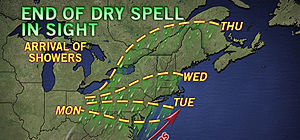
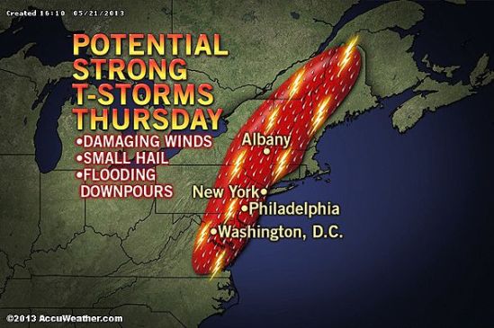
The same storm system responsible for producing violent and deadly thunderstorms in Oklahoma recently will reach the northeast for Thursday. The nature of the storms will change somewhat from producing tornadoes to more of a straight-line wind gust, hail and flash flooding event. However, there is a chance that a couple of the strongest thunderstorms will produce a brief tornado.

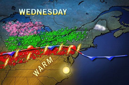
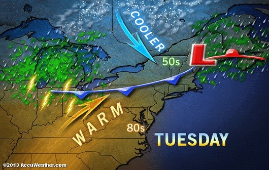
The risk for damaging and dangerous thunderstorms is forecast to extend from eastern Virginia to eastern New York state and portions of New England. Much of this area will be in a sea of warm, humid air as a cool front providing a focusing point for the storms arrives.Only the immediate coast of southern and eastern New England would be spared the worst of the gusty storms, due to a flow of cool air off the ocean. People should be prepared for travel problems, sporadic power outages, frequent lightning strikes and urban flooding Thursday afternoon and evening. -SS

Enjoy today! Storms tonight to tomorrow

Enjoy today! Storms tonight to tomorrow

There is the potential for locally gusty thunderstorms to affect portions of Ohio, Pennsylvania, West Virginia, Maryland, Virginia and upstate New York Friday and Friday night and then areas farther east on Saturday.

The storms will bring a risk of damaging wind gusts, hail, blinding downpours and flash flooding to a few locations. A disturbance will track east-northeastward from the Midwest, along a slowly advancing cool front. The disturbance will raise the intensity of thunderstorms along the frontal zone.

During Saturday, the risk of locally damaging thunderstorms will shift to part of the I-95 corridor from Raleigh, N.C., to Washington, D.C., Philadelphia and New York City. In areas that have received heavy rain recently, there is an elevated risk of flash and small stream flooding. Stay safe and Happy mother’s Day! -SS

End of this gorgeous weather

End of this gorgeous weather

The storm that brought historic snow to the the nation’s midsection will finally reach the Northeast during the upcoming week, once the high pressure responsible for the current dry spell breaks down.
The showers are expected to reach Washington, D.C., Monday afternoon, Philadelphia, Pa., and Trenton, N.J., by Tuesday, Albany, N.Y., and Boston, Mass., on Wednesday and Burlington, Vt., and Bangor, Maine, on Thursday.

The best chance for showers to move into our area will be from the daytime on Wednesday into the day on Thursday. After that it looks to clear out and stay warm! -SS

Heavy storms still moving east

Heavy storms still moving east

The storms and downpours are expected to increase in strength due to the building warmth of the afternoon and then remain strong into the evening.

Spotty showers will occur ahead of the line of storms and downpours during the day Friday and Friday evening. A prevailing cool wedge of air and/or clouds may limit the intensity of the storms over central and eastern New England.

Some locations can be hit by more than just a downpour and some lightning and thunder. A few places can have a severe thunderstorm that brings strong winds, torrential downpours and hail. As a result, there is the potential for downed trees, power outages and flash flooding in the vicinity of the storms.

The greatest chance of severe weather stretches from part of southeastern Pennsylvania to coastal South Carolina from late Friday afternoon into the evening.

The storms are the remnants of a squall line that affected the Central states with severe thunderstorms and flooding during the middle of the week.

It will not be until the evening before they reach most places along the middle and southern Atlantic coast and generally not until the overnight and early Saturday morning hours before they reach the east coast of New England.

There is the potential for 1-2 inches of rain along a large part of the Atlantic Seaboard later Friday and Friday night. -SS

Rains a coming

Rains a coming

Showers and thundershowers will move into the area this evening. This front that i have been talking about for a week will drop south through the area today and bring with it the monster storm out of the plains, This is a beast of a storm as it has dropped over 2 feet of snow in some parts, and also tornadoes and severe storms. We have the chance for storms in the forecast, but nothing severe should make it up this way. The showers will continue all the way into Friday, and the entire area can expect 1-2 inches of rain over the next couple days.

The weather looks to again be cooler when the storm passes, and into next week. For everybody that loved the summer warm-up the last couple days, don’t get used to it as we shouldn’t even hit 60 degrees until midweek next week. Stay dry! -SS

Still on the good side of the front

Still on the good side of the front

As the cold front is still north of us, the warm air will push further north today. It will give us our warmest temps so far this year. Some record highs have already been recorded in parts of NY state. Do what you gotta do, take off work, call out, just get outside and get some sun. This warm weather will only last into tomorrow as the front drops down to the south of us and brings showers and cooler weather with it. Get outside! -SS

Enjoy Today!

Enjoy Today!

What a stellar day today! Nicest day of the year so far! Enjoy it now, because it is not going to last. Remember last week I posted about that stationary front for this week? Well today we are on the warm side, but after tomorrow or even Wednesday, the front will drop back down to the south of us, dropping us back into the 40s and 50s with some showers around for the rest of the week.There is still a chance it stops just north of us, and we could even be approaching the 70s tomorrow and Wednesday. It’s tough to say right now where it will set up. Stay tuned and get outside and enjoy today! -SS

Storm off the coast moving out to sea

Storm off the coast moving out to sea

The big coastal storm that we were watching today, will just miss us. As you can see we are right on the very edge of this storm. Throughout the day it will move farther away an in turn we will get sunnier and warmer. Unfortunately right on the heels of this storm is a cold front that will move through tonight. It doesn’t have much precipitation with it, but it will cool it down somewhat. Tomorrow looks to be beautiful and sunny but chillier again. As highs will struggle to reach 50 degrees. Into next week we will be dealing with that stalled out stationary with associated Showers and cooler temps for most of the week. -SS