Flooding rains today

Flooding rains today

There will be a widespread swath of 1-2 inches of rain today. This combined with lots of melting snow pack will make the conditions favorable for minor to moderate flooding. In the urban areas, there are still covered and blocked storm drains which are causing some ponding of roads. In outlying areas, small streams and rivers are being filled up by the rain and melting snow. Take it slow out there, and remember not to drive through any water covered roadway. You don’t know how deep the water could be! Stay dry! -SS

20th anny Blizzard of ’93

20th anny Blizzard of '93

This week is the 20th anniversary of the ‘Storm of the Century’. This is one the biggest and strongest winter storms of all time. It impacted over 140 million people over a very large area. This storm left one of the largest and deepest snow fields in history. The storm produced an extremely rare, massive swath of 1 to 3 foot snowfall from the gulf coast all the way up into Canada. In today’s dollars, losses from the storm would cost around $7 billion. In the U.S., over two dozen states were touched by the storm. The storm directly or indirectly impacted approximately 40 percent of the population of the U.S. This storm will go down in history as one the largest and strongest storms of all time.

Back to our current weather, we have quite a large powerful storm set to impact the region on Tuesday. Be prepared for soaking rains of over an inch for most of the area! It will clear out for Wednesday, but before it leaves it will usher in some much colder air into the region. -SS

Who did their snow dance?

Who did their snow dance?

Well its been a rough couple days for the forecasters in New England. First the snow for Wednesday night doesn’t come together. Then the storm explodes into a monster last night into today. The winter weather advisory that was posted for southern CT expired at 10 am, but they promptly posted a winter storm warning until 6 pm tonight for total snow accumulations of 6-12 inches. A couple blown forecasts is tough to handle, but this was and is a complex storm that went through many changes and phases.

There is a general 6-8 inches down, with higher elevations seeing a bit more! The radar is still pumping, and it should snow for most of the day. With temperatures right around freezing, the roads should clear up fast once they are plowed.

Looking ahead, I’m seeing 50s start to show up for high temps early next week, so there is some light at the end of the tunnel.

Hope that you all are enjoying it for me as I am still in Vail doing some skiing. There is now a winter storm warning posted for Vail with 1-2 feet expected tonight into tomorrow. I’m sorry I missed that storm back east, but I’ll have my own storm to enjoy tonight. Stay safe! -SS

Revised Snow Map

Revised Snow Map

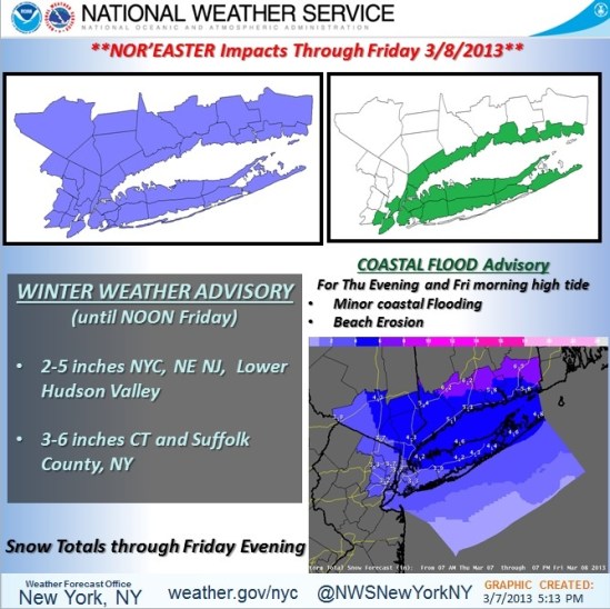
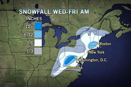
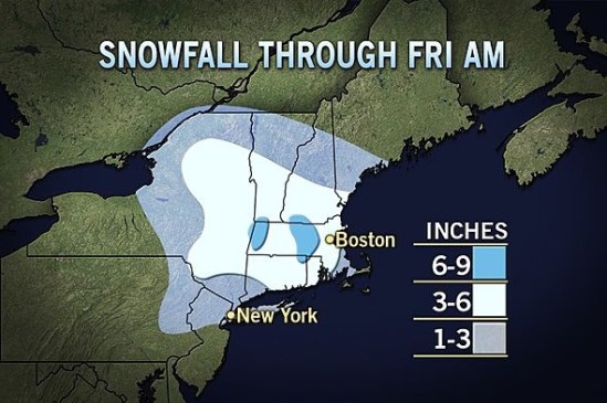
This map is still showing a general 3-6 for most of the state with the exception of the coast from New Haven on west. There they should still expect to see 1-3 inches.

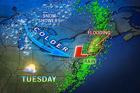
There is now a coastal flood advisory posted for the entire shoreline. Minor to moderate flooding is expected in vulnerable coastal areas and shore roads. Locations that are still recovering from hurricane Sandy need to heed warnings and take the necessary precautions.

There is also a wind advisory for sustained winds of 20-30 mph with gusts to 50. This combined with the heavy wet snow will make the chance for power outages to increase into the overnight.

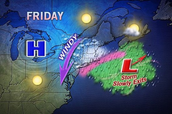
Rain showers will continue into the evening and eventually change over to snow during the overnight period. New Haven and the surrounding area will get 2-3 inches of heavy wet snow tonight.the precipitation will mix with and change back over to rain as temperatures rise above freezing during the day tomorrow. As the storm slowly pulls away, it will interact with an upper level low moving in from the Great Lakes area. This will produce some heavier bands of snow to form back over the area tomorrow night. These could produce another 2-3 inches of snow. The snow will taper off on Friday, and end as a mix of rain and snow or just plain rain showers.

Since it is March, and the sun is getting a little higher in the sky, I don’t expect any snow to stick around for very long after the storm. The weather for the weekend looks beautiful with highs almost near 50 and abundant sunshine.

Enjoy the storm! I will hopefully be able to post again tonight but not until about 10 or 11pm. I am currently boarding a plane to Denver, CO! -SS

Snow’s a coming

Snow's a coming

Well the advisories are posted, and this beast of a storm is knocking on our doorstep. It’s looking like It should start up this afternoon as just some rain showers here in southern CT. As the day goes on, and the precipitation increases, it will mix with and change to snow. It should snow most of the night, dropping about 3-6 inches into tomorrow. Tomorrow it should go to just a light mix of rain and snow showers, but as the storm pulls away and interacts with an upper level low it should bring some heavier bands across the area again tomorrow night. That should drop an additional 1-3 inches.

I am on my way to NYC to catch a flight to Denver, CO. I will be skiing Vail for the weekend and will miss this storm. Hopefully my flight is good for a 5pm departure. We’ll see how windy it is down that way. I will not be able to post much, but i will do my best. Enjoy the storm and watch for very strong winds and coastal flooding tonight. -SS

Saturn snow map

Saturn snow map

As of today, It looks like most of Connecticut should see over 6 inches of snow!!!! This is a big change from over the last couple days! Precipitation should start tommorrow afternoon and last all the way until Friday for eastern sections.

This is a very complex and potent storm that needs to be taken very seriously! it will not take much of a shift in storm track to double these current projections of snowfall! Stay tuned! lots to come- SS

***NOT A MISS***

***NOT A MISS***

Remember that scenario map i posted a few days ago?? Well for a couple days it looked like that wasn’t going to play out. Then last night i started seeing models pushing this storm closer and closer to us, and when I woke up today and the models are now coming into agreement.

This storm is going to explode over the Atlantic Ocean, and it appears it is going to be close enough to drop significant rain and snow over Connecticut. This is still a very complex and ever changing storm that we will need to watch very closely.

This storm has wavered back and forth everyday this week, and I am sure it is going to change again. As of now I hate to say it but batten down the hatches yet again and brace for prolonged coastal flooding and very strong winds. With gusts on the coast of 50-70 mph! More to come! -SS

Expected snowfall

Expected snowfall

This map shows the total snowfall expected from Wednesday into Thursday. It shows all of the snow staying to our south this time around. As of tonight it is looking like we might slip into the extreme northern edge of this storm and get a little something in the way of rain and snow showers Wednesday night into Thursday. We will definitely be seeing very strong winds and some coastal flooding no matter which track it takes. It still looks like we will not be taking the brunt of this storm here in southern CT, but don’t let your guard down yet there is still an outside chance it takes a left and drops some heavier snow and rain. Stayed tuned -SS