Watching coastal storm for biggest travel day of year!

Watching coastal storm for biggest travel day of year!

All eyes are now on the potential winter storm for midweek next week. This is a tough time for a big storm, as this is one of the biggest travel times of the year.

The painful blast of wind-driven Arctic air set to invade the Plains this week and East this weekend will fade in most areas while a storm sinking southward in the West will slowly move east. The speed at which this storm moves along and how sharp of a left turn the storm takes later next week is uncertain.

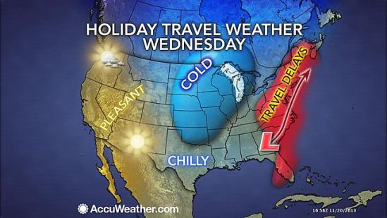
For most areas along the East Coast and South, it will be a question of rain or not on Tuesday, Wednesday and Thanksgiving Day. Rain, poor visibility and low ceilings alone on Wednesday can lead to its share of major delays.

However, just enough chilly air may be in place beginning around the central Appalachians northward to New England for snow and ice, depending on the track, strength and timing of that Gulf Coast storm, which is likely to become an Atlantic coast storm.

Early indications are the storm would swing northeastward across the Appalachians and I-95 corridors later Tuesday, Wednesday into Wednesday night. Details as to when and where the storm will have the most impact will unfold later this week into this weekend.

I’ll keep everyone posted as this storm comes together and takes shape! -SS

Imminent Destruction in the Philippines from Super Typhoon Haiyan

Imminent Destruction in the Philippines from Super Typhoon Haiyan

Super Typhoon Haiyan (local name Yolanda) is bringing a significant risk to lives and property as the monster storm moves across the Philippines. I feel the need to blog about this storm, because of how intense this storm is. It is truly an awesome storm.

On Friday, the sustained winds with this exceptionally dangerous storm increased to 315 kph (195 mph), surpassing the winds of Super Typhoon Lekima, which was previously the strongest tropical system in the world for the 2013 season based on wind speed and central pressure. I can’t even imagine what 200 mph sustained winds are going to do to that part of the world. It’s going to be ugly.

The strength of Haiyan is equal to that of an extremely powerful Category 5 hurricane in the Atlantic.

Widespread torrential rain and damaging winds will accompany Haiyan through the central Philippines, threatening to leave a trail of destruction and triggering life-threatening flash floods.

Rain totals along the path of Haiyan could top 200 mm (8 inches). Mudslides are a serious concern in the higher terrain, where localized totals of 250 to 300 mm (10 to 12 inches) are possible.

Good Luck to everyone in that part of the world, and send some prayers their way as they will need it as they deal with one of the strongest storms we’ve ever seen. -SS

More flooding rains for Monday

More flooding rains for Monday

Flooding downpours will return to the Northeast on Monday, targeting areas just hit by Andrea.
Numerous showers and thunderstorms will move into the interior Northeast by Monday morning before advancing toward the coast into the evening.
The wet weather is in response to an advancing storm fueled by humid air. Andrea shattered June rainfall records late last week across southern New England. This will make the region extremely vulnerable to flooding on Monday as downpours return. Numerous downpours will extend into the region by the evening commute and can quickly flood small streams and overtake storm drains in the region. Ponding on roadways will be widespread in the region, particularly in urban areas. Don’t drive through water covered roads out there! Stay safe! -SS

Strong storms Sunday

Strong storms Sunday

A widespread area from the northeast to the mid-atlantic should be on the lookout for strong to potentially severe storms on Sunday. Damaging winds and flooding downpours are the main threats from the strongest thunderstorms, which will generally be confined to the afternoon and evening hours. If any tornado touches down, it would be an isolated event.

As the weekend comes to an end, so will the threat for severe weather across the Northeast. Showers and less-intense thunderstorms will linger along the I-95 corridor on Monday as cooler and less humid air moves in behind the storms. -SS

Strong storms today!!

Strong storms today!!

The same storm system responsible for producing violent and deadly thunderstorms in Oklahoma recently will reach the northeast for Thursday. The nature of the storms will change somewhat from producing tornadoes to more of a straight-line wind gust, hail and flash flooding event. However, there is a chance that a couple of the strongest thunderstorms will produce a brief tornado.

The risk for damaging and dangerous thunderstorms is forecast to extend from eastern Virginia to eastern New York state and portions of New England. Much of this area will be in a sea of warm, humid air as a cool front providing a focusing point for the storms arrives.Only the immediate coast of southern and eastern New England would be spared the worst of the gusty storms, due to a flow of cool air off the ocean. People should be prepared for travel problems, sporadic power outages, frequent lightning strikes and urban flooding Thursday afternoon and evening. -SS

Hold off on those beach plans

Hold off on those beach plans

The Memorial Day weekend will begin cool, windy and rainy in New England. The storm system responsible for severe weather and deadly tornadoes over the Plains earlier this week will give birth to a new storm over the Northeast as the week draws to a close and the holiday weekend begins.

The event will start as locally severe thunderstorms Wednesday evening into Thursday evening spreading slowly from the Appalachians to the East Coast. As the storm strengthens, it will cause winds to kick up and will make a pocket of cool air in the region.

Friday night into Saturday could be a flat-out nasty way to start the summer season with a driving wind, rain and temperatures in the 50s and lower 60s in many locations. It might be crazy to think, but it is not entirely out of the question that it gets cold enough for the highest elevations of the Northeast, especially the Adirondacks, Green and White mountains to have wet snowflakes mixing in during the first part of the weekend.

The storm will squeeze out a great deal of moisture from the atmosphere, while drawing additional moisture in from the Atlantic Ocean. The period from Thursday to Sunday bring 4 or more inches of rain to some locations with isolated incidents of flash and urban flooding.

The storm will slowly spin off to the northeast during the second half of the weekend with improving weather conditions and rebounding temperatures. However, portions of New England may hold on to clouds, spotty rain and drizzle through Sunday and possibly into Monday morning-SS

Enjoy today! Storms tonight to tomorrow

Enjoy today! Storms tonight to tomorrow

There is the potential for locally gusty thunderstorms to affect portions of Ohio, Pennsylvania, West Virginia, Maryland, Virginia and upstate New York Friday and Friday night and then areas farther east on Saturday.

The storms will bring a risk of damaging wind gusts, hail, blinding downpours and flash flooding to a few locations. A disturbance will track east-northeastward from the Midwest, along a slowly advancing cool front. The disturbance will raise the intensity of thunderstorms along the frontal zone.

During Saturday, the risk of locally damaging thunderstorms will shift to part of the I-95 corridor from Raleigh, N.C., to Washington, D.C., Philadelphia and New York City. In areas that have received heavy rain recently, there is an elevated risk of flash and small stream flooding. Stay safe and Happy mother’s Day! -SS

Showers again today

Showers again today

Bands of heavy rain and thunderstorms will spiral around a slow-moving, land-based storm over the mid-Atlantic.

It is the same storm which brought record May snowfall to parts of the Plains last week and flooding over the past weekend to portions of the Midwest and South.

The rain bands will shift around with time and breaks of sunshine are possible in between. The storm can produce a couple of inches of rain locally over a several-hour period, which is more than enough to cause flooding problems and travel delays. This was the case around New York City on Wednesday, where over three inches of rain fell in a relatively short amount of time.
-SS

Heavy storms still moving east

Heavy storms still moving east

The storms and downpours are expected to increase in strength due to the building warmth of the afternoon and then remain strong into the evening.

Spotty showers will occur ahead of the line of storms and downpours during the day Friday and Friday evening. A prevailing cool wedge of air and/or clouds may limit the intensity of the storms over central and eastern New England.

Some locations can be hit by more than just a downpour and some lightning and thunder. A few places can have a severe thunderstorm that brings strong winds, torrential downpours and hail. As a result, there is the potential for downed trees, power outages and flash flooding in the vicinity of the storms.

The greatest chance of severe weather stretches from part of southeastern Pennsylvania to coastal South Carolina from late Friday afternoon into the evening.

The storms are the remnants of a squall line that affected the Central states with severe thunderstorms and flooding during the middle of the week.

It will not be until the evening before they reach most places along the middle and southern Atlantic coast and generally not until the overnight and early Saturday morning hours before they reach the east coast of New England.

There is the potential for 1-2 inches of rain along a large part of the Atlantic Seaboard later Friday and Friday night. -SS