Severe storms possible

Severe storms possible

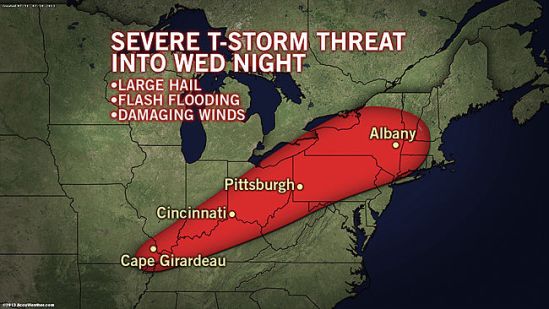
As a cold front swings through the region on Wednesday, two very different air masses will collide. The drier air from the northern Plains will meet the steamy air coming from the Southeast into the mid-Atlantic. The merge of dry air and very moist air will create favorable conditions for thunderstorms, some of which may be severe.
The main threats with these storms will be torrential downpours, damaging wind gusts in excess of 60 mph and even some hail. -SS

Projected snow map

Projected snow map

Well here comes another big complex storm into the area for Monday night into Tuesday. Inland portions of the northeast could see well over a foot from this storm!! Closer to the coast of Connecticut, we should only see a slushy inch or two before it mixes and changes to rain on Tuesday morning. This is going to have to be watched closely as some spots might hang close to the freezing mark early Tuesday, and there could be a prolonged period of freezing rain.

This will heavily impact travel for the Tuesday morning commute! Take the necessary precautions and take it slow out there! Any spots that get a substantial amount of this heavy wet snow, need to be prepared for the chance of power outages. The wet snow will cling to the tree limbs and power lines, and the strong winds will combine to bring many of these limbs and power lines down! Stay tuned for the latest! -SS

Potential major storm next week

Potential major storm next week

This storm is currently over the northern Pacific, and it’s looking to cause cross-country trouble next week, from the northern Rockies to the Midwest and eventually to us in the Northeast.

Early indications are that the storm will grow large and strong after negotiating the Rockies this weekend. It will have an opportunity to tap into Gulf of Mexico and Atlantic moisture as it progresses eastward during the first part of next week.
A storm of this nature has the potential to bring strong wind as well as areas of heavy snow on its northern flank, strong thunderstorms on its southern flank and drenching rain in the middle.
Like many storms a week or so away, the track is key to determining where the boundary of rain and snow will set up. We will have to wait and see how much warm air gets pulled into this storm as it makes it’s way east. Ill keep you posted on this evolving storm. -SS

Flooding rains today

Flooding rains today

There will be a widespread swath of 1-2 inches of rain today. This combined with lots of melting snow pack will make the conditions favorable for minor to moderate flooding. In the urban areas, there are still covered and blocked storm drains which are causing some ponding of roads. In outlying areas, small streams and rivers are being filled up by the rain and melting snow. Take it slow out there, and remember not to drive through any water covered roadway. You don’t know how deep the water could be! Stay dry! -SS