This week is severe weather awareness week here in New England.
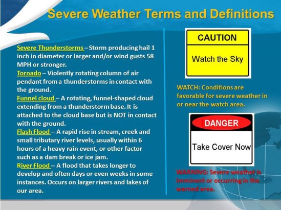
Here are some severe weather terms and definitions.
Severe thunderstorms are defined as those thunderstorms that produce winds of 58 mph or greater and or hail of one inch in diameter or larger. A Severe Thunderstorm Watch means that severe thunderstorms are possible over the next several hours. You should continue with your daily routine…but be prepared to move to a place of safety should a Severe Thunderstorm Warning be issued. A Severe Thunderstorm Warning means that severe thunderstorms are imminent or occurring. A warning implies a significant threat to life and property. You should seek shelter immediately when a Severe Thunderstorm Warning is issued.
Tornadoes are violently rotating columns of air in contact with the ground and attached to the cloud base above. Like a Severe Thunderstorm Watch…a Tornado Watch means that tornadoes are possible over the next several hours. A Tornado Warning means that a tornado is imminent or occurring. A Tornado Warning implies an immediate threat to life and property. Take shelter in a basement or interior room immediately.
Flash flooding is a rapid rise of water along a stream or low lying urban area. The most common cause of flash flooding is downpours associated with thunderstorms. A Flash Flood Watch means that conditions are favorable for flash flooding. Continue with your daily activities…but be prepared to head to a place of safety should a Flash Flood Warning be issued. A Flash Flood Warning means that flooding is imminent or occurring. Flood waters can rise rapidly. Seek High Ground immediately when a Flash Flood Warning is issued.
The National Weather Service issues severe thunderstorm, tornado, and flash flood warnings for the area likely to be impacted by the storm. Rather than for an entire County. This method Narrows the region for which a warning is valid, eliminating unnecessary warnings for areas of a County where no threat exists.
Severe weather season is right around the corner. Know these terms to better protect your life and property. Stay safe! -SS


