End of this gorgeous weather

End of this gorgeous weather

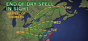
The storm that brought historic snow to the the nation’s midsection will finally reach the Northeast during the upcoming week, once the high pressure responsible for the current dry spell breaks down.
The showers are expected to reach Washington, D.C., Monday afternoon, Philadelphia, Pa., and Trenton, N.J., by Tuesday, Albany, N.Y., and Boston, Mass., on Wednesday and Burlington, Vt., and Bangor, Maine, on Thursday.

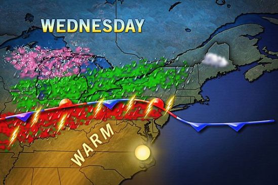
The best chance for showers to move into our area will be from the daytime on Wednesday into the day on Thursday. After that it looks to clear out and stay warm! -SS

Rains a coming

Rains a coming

Showers and thundershowers will move into the area this evening. This front that i have been talking about for a week will drop south through the area today and bring with it the monster storm out of the plains, This is a beast of a storm as it has dropped over 2 feet of snow in some parts, and also tornadoes and severe storms. We have the chance for storms in the forecast, but nothing severe should make it up this way. The showers will continue all the way into Friday, and the entire area can expect 1-2 inches of rain over the next couple days.

The weather looks to again be cooler when the storm passes, and into next week. For everybody that loved the summer warm-up the last couple days, don’t get used to it as we shouldn’t even hit 60 degrees until midweek next week. Stay dry! -SS