Newest Snow Map

Newest Snow Map

As you can see with this latest map, the extent of heavier snow has greatly increased. 3-6 inches can now be expected all the way to the coast of Connecticut. Interior sections are looking at a widespread area of over one foot!!

This map doesn’t show the accumulation of ice on top of that snow. Southern New England could get up to an additional half inch of ice. This accompanied with the heavy wet snow and strong winds till take down lots of trees and power lines in the heavily iced areas. Stay Tuned! -SS

HERE WE GO

HERE WE GO

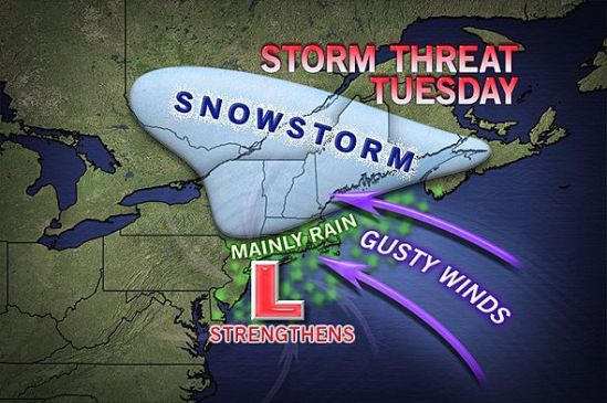
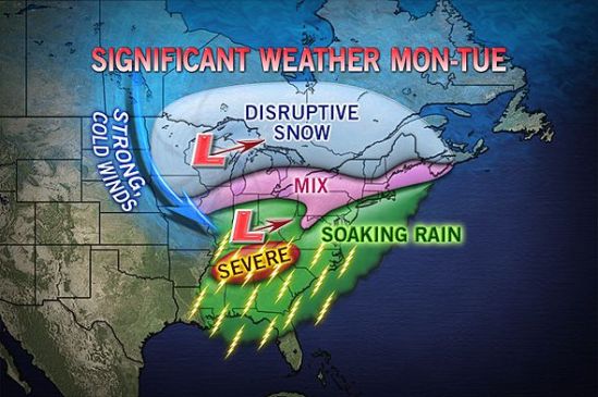
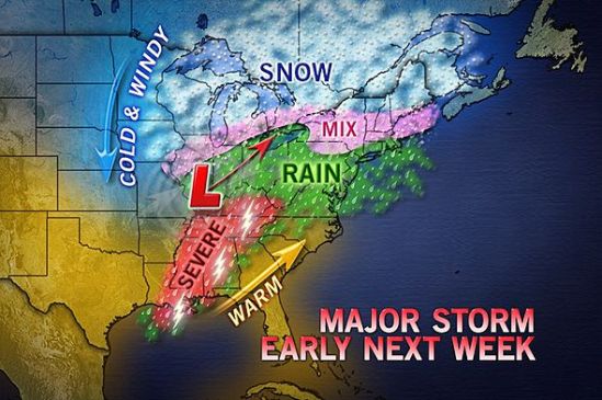
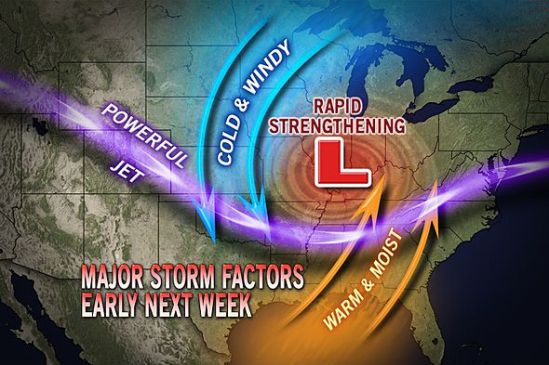
I’m not even sure where to start with this today!! All the ingredients are coming together to make this a monster storm. This storm will begin to move into the area tonight with snow for all locations. The snow will continue into the overnight, but this is where it gets tricky. As this storm moves in, it is going to transfer its energy to a new storm which will develop off of the New Jersey coast and move to the north or northeast.

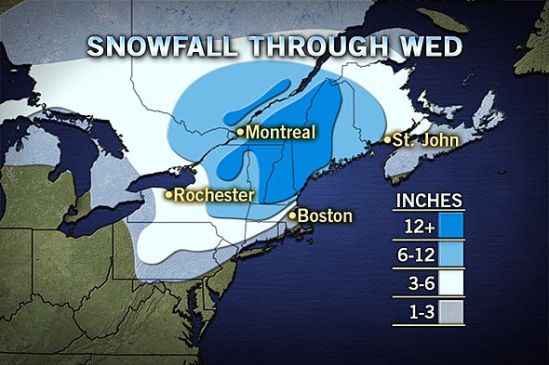
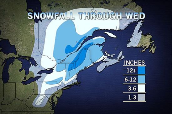
This is going to be a tough one to call, when the new storm forms and then strengthens, so will the east and northeast winds. They will usher in lots of moisture, but also some warmer air aloft. The warm air will fill in the upper levels of the atmosphere, but not at the surface. This will lead to a prolonged period of sleet and freezing rain. This could fall heavy at times late tonight into Tuesday morning. This will be a tough one for accumulations, but it now looks like a general 3-5 inches all the way to New Haven. There will be some higher elevations in the hills of Connecticut that see 6-10 inches. If you go north from there into northern New England, they will be measuring in FEET of snow. With the ice, some of the valleys in southern Connecticut could be stuck just at or below freezing therefore extending the icing period into the morning. Use extreme caution in icy conditions, as 4 wheel drive does not help with braking on icy surfaces. There will be an accumulation of ice and sleet on top of the fallen snow which will make for extremely dangerous conditions.

This is a very potent storm that needs to be watched closely. The end of the afternoon commute tonight could get sloppy, but the main concern will be the Tuesday morning commute. Expect numerous school closings and delays for Tuesday. More to come! -SS

Projected snow map

Projected snow map

Well here comes another big complex storm into the area for Monday night into Tuesday. Inland portions of the northeast could see well over a foot from this storm!! Closer to the coast of Connecticut, we should only see a slushy inch or two before it mixes and changes to rain on Tuesday morning. This is going to have to be watched closely as some spots might hang close to the freezing mark early Tuesday, and there could be a prolonged period of freezing rain.

This will heavily impact travel for the Tuesday morning commute! Take the necessary precautions and take it slow out there! Any spots that get a substantial amount of this heavy wet snow, need to be prepared for the chance of power outages. The wet snow will cling to the tree limbs and power lines, and the strong winds will combine to bring many of these limbs and power lines down! Stay tuned for the latest! -SS

Big coastal storm for Tuesday

Big coastal storm for Tuesday

As it looks right now, northern New England looks to be in the bulls eye for heavy snow on this one. This storm will move in later in the day on Monday. It could start as some snow or mixed precipitation for everybody all the way to the coast. The storm will strengthen off the coast and wrap in lots of moisture and warmer air which will change any mix or snow to all rain for Connecticut. There are still some uncertainties with the exact track, and a little deviation could mean more snow for parts of Connecticut. As it gets closer, we will have a better idea of how much snow! I will keep you posted! -SS

Still watching early week storm

Still watching early week storm

This storm is still something to watch. It looks like a big mess of precipitation coming into the area sometime Monday afternoon or evening. It will drop some heavy snow inland and a mix of precip for the coast. There is going to be more coastal flooding and also wind gusts of 50-60 mph. As it gets closer we”ll have a better idea of what kind and how much precip will fall. I’ll keep you posted! -SS

Potent storm potential next week

Potent storm potential next week

We are also watching the chance of a potent storm coming together somewhere in the time frame of Monday-Wednesday for the northeast. While it looks to be a mainly rain event here in Connecticut, inland portions need to watch this very closely. It could drop a good deal of heavy wet snow and rain on already very saturated soil from this weeks rain and melting snow. This will pose a flooding risk for lots of people in its path. This is something to watch, and I will keep you posted! -SS

Still Watching Clipper

Still Watching Clipper

We still have our eyes on a fast moving relatively weak storm for Friday night into Saturday night. This shouldn’t be more than wintry mix from Friday night into just plain rain during the day on Saturday. It may mix with or change back to snow for Saturday night. All in all there is not a lot of precipitation associated with this, but we still need to watch it. -SS

Quick Clipper for the Weekend

Quick Clipper for the Weekend

Looks like an Alberta clipper will be sinking its way out of Canada just in time for the weekend. This is not a strong storm, and it is quick moving, but some spots could pick up a little snow, so it’s worth mentioning. Saturday into Saturday night rain and snow showers will move in, with higher terrain and inland sections seeing the best chance for accumulating snow. This isn’t a major storm, just a nuisance.

The trend is going to stay active, as there is another clipper hot on its heels for Sunday night. Also, as i mentioned yesterday, we are still watching the chance for a monster storm for the middle of next week! Stay tuned! -SS

Potential major storm next week

Potential major storm next week

This storm is currently over the northern Pacific, and it’s looking to cause cross-country trouble next week, from the northern Rockies to the Midwest and eventually to us in the Northeast.

Early indications are that the storm will grow large and strong after negotiating the Rockies this weekend. It will have an opportunity to tap into Gulf of Mexico and Atlantic moisture as it progresses eastward during the first part of next week.
A storm of this nature has the potential to bring strong wind as well as areas of heavy snow on its northern flank, strong thunderstorms on its southern flank and drenching rain in the middle.
Like many storms a week or so away, the track is key to determining where the boundary of rain and snow will set up. We will have to wait and see how much warm air gets pulled into this storm as it makes it’s way east. Ill keep you posted on this evolving storm. -SS

20th anny Blizzard of ’93

20th anny Blizzard of '93

This week is the 20th anniversary of the ‘Storm of the Century’. This is one the biggest and strongest winter storms of all time. It impacted over 140 million people over a very large area. This storm left one of the largest and deepest snow fields in history. The storm produced an extremely rare, massive swath of 1 to 3 foot snowfall from the gulf coast all the way up into Canada. In today’s dollars, losses from the storm would cost around $7 billion. In the U.S., over two dozen states were touched by the storm. The storm directly or indirectly impacted approximately 40 percent of the population of the U.S. This storm will go down in history as one the largest and strongest storms of all time.

Back to our current weather, we have quite a large powerful storm set to impact the region on Tuesday. Be prepared for soaking rains of over an inch for most of the area! It will clear out for Wednesday, but before it leaves it will usher in some much colder air into the region. -SS