2-4 inch snowfall today!

2-4 inch snowfall today!

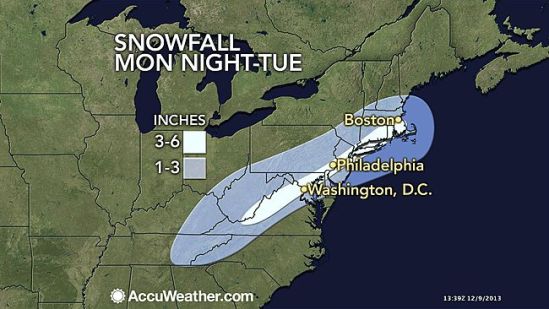
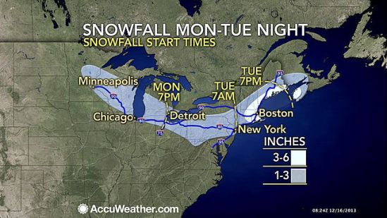
A new system started in the Midwest Monday, but tracks into the Northeast today. It is an Alberta clipper, meaning the storm originates from Alberta, Canada. Usually these systems are very weak, and don’t drop a lot of snow, but this one is a little different. This storm is going to transfer it’s energy to a newly forming coastal low, and drop a widespread light to moderate snow accumulation. By the time this storm really gets going, it will already be moving away from the coast of New England, and it will be moving too fast to really unleash its full fury on the northeast. Here in Connecticut, the snow will start around 8 or 9 am an last until 4 or 5 pm. it will be a tough call for schools, because of the start times, but i imagine there will be a good amount of closings and early dismissals around the state. Drive safe and take it slow out there! -SS

More wintry weather for Tuesday

More wintry weather for Tuesday

The Northeast will have another round of accumulating snowfall early this week, right on the heels of the weekend winter storm. Most locations will pick up 1 to 3 inches of snow from this storm. However, the worst of the snow looks to fall across the I-95 corridor with 3 to 6 inches of snow in the forecast for cities such as New York, Philadelphia, Washington, D.C., Boston and Baltimore. Unlike the storm this past weekend that brought a combination of snow, sleet and freezing rain to the region, precipitation looks to fall mainly as snow in the Northeast with rain farther to the south. Snow will come to an end on Tuesday night across the region as the storm quickly tracks off the East Coast. -SS

Stevie Storms is back, and so is the chance of snow!

Stevie Storms is back, and so is the chance of snow!

Hello again everybody!! I took a little hiatus from blogging as the weather has been nice and fairly tranquil! With no real tropical threats this year, we finally get a break from the major storms. That doesn’t mean there won’t be snow storms though. As we are now only a couple weeks into the fall, we are already talking about a chance of snow here in the northeast. A cold blast of air, driving into the Eastern states, may set the table for a swath of snow next week from the Ohio Valley to New England.

A few temperature swings are likely through the weekend from the Upper Midwest to the Southeast before a large zone of cold air builds into the area next week.
Although the exact track of a potential storm system and impacts will need to be ironed out over the next several days, it is likely that the coldest air of the season will dive into the Midwest Monday, followed by the Ohio Valley and potentially to us here on the East Coast by midweek.

A few storm scenarios exist. One is that a coastal low develops near the Carolinas and slides up the East Coast, bringing coastal rain, inland snow and gusty winds.

Another possible option is that this low does not make the turn up the coast and slides out to sea instead. This track would favor a rain and snow mix for the central Appalachians with dry, cold conditions in New England.

A third scenario depicts an unusually strong storm that moves up the coast then backs into the Northeast. This type of setup would lead to heavy snow well inland but rain in the big cities of the I-95 corridor.

This storm is still a week away and nothing is certain, but it is something that needs to be watched! Glad to be back and talk to you all soon! -SS