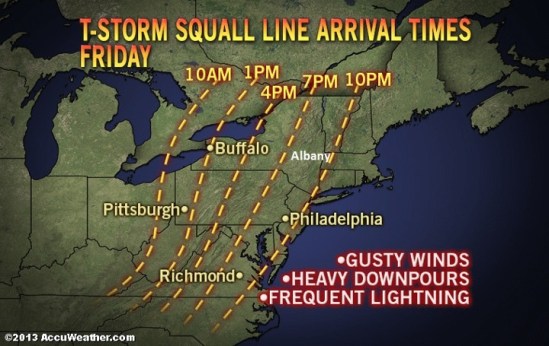
The storms and downpours are expected to increase in strength due to the building warmth of the afternoon and then remain strong into the evening.
Spotty showers will occur ahead of the line of storms and downpours during the day Friday and Friday evening. A prevailing cool wedge of air and/or clouds may limit the intensity of the storms over central and eastern New England.
Some locations can be hit by more than just a downpour and some lightning and thunder. A few places can have a severe thunderstorm that brings strong winds, torrential downpours and hail. As a result, there is the potential for downed trees, power outages and flash flooding in the vicinity of the storms.
The greatest chance of severe weather stretches from part of southeastern Pennsylvania to coastal South Carolina from late Friday afternoon into the evening.
The storms are the remnants of a squall line that affected the Central states with severe thunderstorms and flooding during the middle of the week.
It will not be until the evening before they reach most places along the middle and southern Atlantic coast and generally not until the overnight and early Saturday morning hours before they reach the east coast of New England.
There is the potential for 1-2 inches of rain along a large part of the Atlantic Seaboard later Friday and Friday night. -SS