Monster Nor’easter for late tonight into Thursday

Monster Nor'easter for late tonight into Thursday

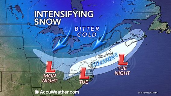
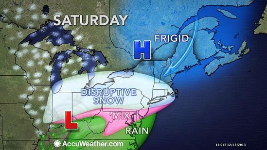
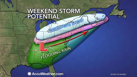
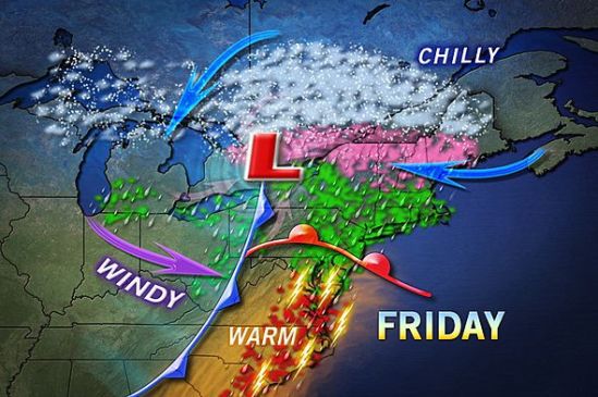
A storm bringing heavy ice and snow to the interior Southeast will reach the Northeast Wednesday night and Thursday with heavy snow and gusty winds. This is a very strong and complex storm! As I write this the storm is dropping a historic ice storm on much of the southeast US! Conditions could be catastrophic down there with hundreds of thousands of people without power. As the storm moves up the eastern seaboard today and tonight it will interact and ‘phase’ with an upper level low pressure system that’s moving out of the mid-west. As these storms phase together and combine their powers to form a super-storm nor’easter, it will create my all time favorite weather term… Bombogenesis!! This means the storm will ‘bomb out’ or rapidly strengthen and intensify as it heads up the northeast coast. This will make for potentially the biggest storm of the year for some parts of the mid Atlantic and northeast. As it moves up the coast the exact track is the key here as a subtle shift of 40-50 miles in storm track could mean the difference between just a couple of inches of snow to well over a foot.
The way it looks now, New Haven can expect 6-10 inches before mixing with and changing to freezing rain and sleet and depending on the exact track, even plain rain in the afternoon tommorow. Even if it does change over, all areas will go back to all snow before ending
Thursday night! Inland CT and MA can expect over a foot with the potential for 14-18 inches where it will stay all snow.
The snow should start in the New Haven area around 2 or 3 am overnight Wednesday into Thursday morning. It will become very heavy in the morning and travel will be very treacherous if not impossible.
The big winner here as it looks now (all could change depending on storm track) will be northwestern CT, western MA, southern VT and NH, and heading northeast into Maine. All schools in CT and across NE should be closed tomorrow. Enjoy your snow day kids and teachers. I will update again tonight as the storm approaches and confidence increases on the exact storm track! -SS

Tuesday Snowstorm taking shape!!

Tuesday Snowstorm taking shape!!

All the ingredients are coming together to bring us a potent storm for Tuesday afternoon into Tuesday night. As a cold front moves through the area today ushering in another arctic blast, it will be setting the stage for a coastal storm tomorrow. As the front drops south through the region, a weak Albert Clipper will swoop down out of Canada and ride along this front. When this storm makes contact with the warmer Atlantic waters, it will blossom into an all out southern New England snowstorm. Winter Storm Warnings have just been posted for New Haven for heavy snow accumulating 6-10 inches! This snow will accumulate rapidly as it will be brutally cold. This allows for a greater snow ratio. Usually we get about ten inches of snow for every inch of rain , but as it will only be around 10-20 degrees tomorrow and tomorrow night, we will be getting more like 20-30 inches of snow for every inch of rain.

Snow should invade the area around 3pm tomorrow. It will get heavier and steadier heading into the evening. It is going to be very windy and wind chills will be below zero Tuesday night. Plan ahead and be careful if you have to be out tomorrow night! Lots more to come with this developing storm! Stay tuned! -SS

Potential Major Winter Storm Thursday into Friday!!

Potential Major Winter Storm Thursday into Friday!!

Two storms will converge on the Northeast on Thursday with the potential for snow. How quickly they get together and strengthen will determine which areas are hit with heavy snow and which areas will have a near-miss. The snowier of two scenarios would suggest that New England will be hit with a powerful nor’easter that produces blizzard conditions, damaging winds and coastal flooding!! Even if the two Thursday storms are slow to converge, they should still wrap enough moisture around to produce a snowstorm over New England. This storm is a couple days away from coming together, and I will do my best to keep you informed of this potential monster nor’easter! -SS

Good looking storm for tomorrow!!

Good looking storm for tomorrow!!

A storm will roll into Connecticut during Saturday, spreading snow and travel delays across the state. While some warmer air will move up with that storm, odds favor an extended period of snow into part of Sunday over much of the state. Accumulations will range from 1 to 3 inches in the southeastern corner of the state, where a change to sleet and rain is likely to around a foot in some northern and western communities, where all snow occurs. In New Haven, we can expect some flurries and snow showers starting around midday, and some heavier snow rolling in between 3 and 4pm. The snow should be steady into the evening hours, but as the storm moves in overnight, the warmer air will be brought up with it and the coast will go to an icy mix of sleet and freezing rain. Some coastal areas will even change to plain rain by Sunday morning. All said and done New Haven should expect 4-8 inches in total from this storm. You won’t have to go too far inland though, to find totals ranging 8-12 inches where the precipitation will stay as all snow. The storm will depart the area Sunday afternoon. Wet and slushy areas will freeze Sunday night, so be alert for areas of black ice. -SS

Watching another storm for the upcoming weekend

Watching another storm for the upcoming weekend

The punches just keep on coming from Old Man Winter with a new storm poised to impact parts of the South, Midwest and Northeast this weekend, threatening to bring travel delays and disruptions to outdoor activities. The storm will affect the Central states Friday night into Saturday and much of the East Saturday into Sunday.

A stripe of heavy snow is most likely to fall over parts of northern Indiana, Ohio and northwestern Pennsylvania, upstate New York, northern New England and neighboring Canada. Cities that could be hit with an all-out snowstorm include Cleveland, Syracuse, N.Y., and Burlington, Vt. Most cities in the I-95 corridor of the Northeast will have a brief period of snow or a wintry mix at the onset, followed by rain at the height of the storm. A change to plain rain is forecast in Washington, D.C., Philadelphia, New York City and Boston. However, it could snow hard prior to a change to rain in part of the coastal Northeast, raising concerns for a period of slippery travel.

The storm will come together over the Deep South Friday and head toward a cold high pressure system moving across the Northeast. The storm will be preceded by the coldest air of the season so far in parts of the Midwest and Northeast. The storm itself will attack the cold air, removing much of it, but squeezing out heavy precipitation in the process.

In the wake of the storm this weekend, a mixture of Arctic and Pacific air is forecast to come in, so it may not feel quite as cold as recent days from the Midwest to the East. The milder air starting next week will allow a break from the wintry precipitation in some areas hit hard, but not everywhere. Just enough cold air will linger in the northern tier states to allow more storms with snow and wintry mix as the the month progresses. -SS

Rains a coming

Rains a coming

Showers and thundershowers will move into the area this evening. This front that i have been talking about for a week will drop south through the area today and bring with it the monster storm out of the plains, This is a beast of a storm as it has dropped over 2 feet of snow in some parts, and also tornadoes and severe storms. We have the chance for storms in the forecast, but nothing severe should make it up this way. The showers will continue all the way into Friday, and the entire area can expect 1-2 inches of rain over the next couple days.

The weather looks to again be cooler when the storm passes, and into next week. For everybody that loved the summer warm-up the last couple days, don’t get used to it as we shouldn’t even hit 60 degrees until midweek next week. Stay dry! -SS

Still on edge

Still on edge

The storm as it looks now, has taken more of a right turn, and will go out to sea. This map still has 1-3 inches for the very immediate coast of Connecticut, but i doubt anyone sees even one inch of snow. This storm will bring nothing more than some mixed rain and snow showers this evening, mainly on the coast. With such a large storm nearby, it will be a little breezy today, and there is a chance for some minor coastal flooding.

On the bright side, the extended forecast is showing no snow at this time, and even a slight warming trend! Stay tuned for spring! -SS

Living on the edge

Living on the edge

Southern Connecticut will be on the northern most edge of this next large winter storm. The track is still not set in stone, and just a little change in track will greatly increase or decrease snowfall! As it looks now, we should only see a slushy inch or two. Snow will start Monday morning and continue through the day. It will mix with rain at times in the afternoon, but into the evening it will change back to all snow. This does not look like a major storm (for us) as it is right now, but it will need to be watched as it could still drop a sneak attack several inches in some places! Keep you posted! -SS

Slop ending as rain today

Slop ending as rain today

As predicted, we got a few inches of snow last night. Overnight as warmer air moved in and temperatures rose above freezing, the snow transitioned to freezing rain, sleet, and finally rain. The rain will taper off to showers later on this evening. Be careful when venturing out as there might still be some slick spots on untreated side roads and sidewalks. Temperatures in a few inland spots are still below freezing, and icing conditions can still exist. Take it slow out there! Off to VT for me to enjoy this fresh powder on the slopes! -SS