Still watching early week storm

Still watching early week storm

This storm is still something to watch. It looks like a big mess of precipitation coming into the area sometime Monday afternoon or evening. It will drop some heavy snow inland and a mix of precip for the coast. There is going to be more coastal flooding and also wind gusts of 50-60 mph. As it gets closer we”ll have a better idea of what kind and how much precip will fall. I’ll keep you posted! -SS

Potential major storm next week

Potential major storm next week

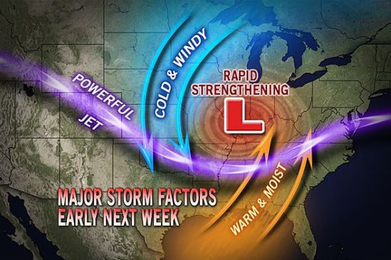
This storm is currently over the northern Pacific, and it’s looking to cause cross-country trouble next week, from the northern Rockies to the Midwest and eventually to us in the Northeast.

Early indications are that the storm will grow large and strong after negotiating the Rockies this weekend. It will have an opportunity to tap into Gulf of Mexico and Atlantic moisture as it progresses eastward during the first part of next week.
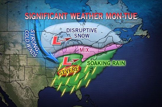
A storm of this nature has the potential to bring strong wind as well as areas of heavy snow on its northern flank, strong thunderstorms on its southern flank and drenching rain in the middle.
Like many storms a week or so away, the track is key to determining where the boundary of rain and snow will set up. We will have to wait and see how much warm air gets pulled into this storm as it makes it’s way east. Ill keep you posted on this evolving storm. -SS

Snow stache!!

Somebody call Mother Nature a doctor cause she is getting sick! Just got done with an epic day skiing at Killington! 8-9 fresh inches on the ground and still dumping!

Best skiing of the year for me as of yet! That all might change next week when I make my first venture to Vail, CO.

I feel bad for all you flat landers stuck with all of those old dirty piles of snow! Make your way up to VT and rejoice in the powder! Heres to knee high powder stashes!! -SS